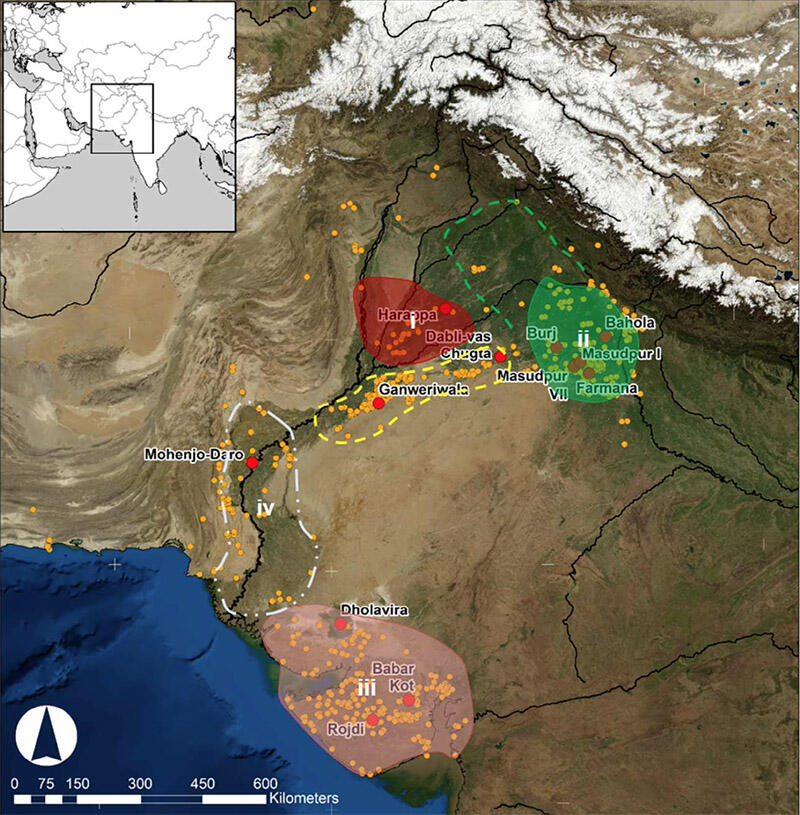
A comprehensive look at what we know about agricultural strategies during the ancient Indus period, and how truly varied and sophisticated these most likely were, with careful adaptation to local conditions and water availability. As the authors write, "The South Asian subcontinent stands out as a region characterised by a number of distinctive forms of early farming, including the exploitation of winter and summer cereals, pulses and fruits (Fuller 2011; Kingwell-Ban- ham et al. 2015), the cultivation of which was enabled (and constrained) by the high level of environmental diversity. The populations of South Asia’s Indus Civilisation, who occupied areas of modern Pakistan and India, made use of a range of these crops and managed to occupy, and thrive in, a zone that straddled an important environmental threshold, where winter and summer rainfall systems overlapped (Fig. 1; Petrie et al. 2016, 2017; Petrie 2017)" (p. 2). As the final map (above shows), the range of the Indus civilization allowed for this diverse set of agricultural strategies to flourish, even if there are still white spaces in our understanding of certain key regions, in part because it is can be difficult to tease out agricultural practices from residues which often contain evidence of more than one crop.
The article includes helpful definitions of "multi-cropping," which can include everything from double cropping (two crops in sequence, to mixed intercropping ("two more more crops at one time with no distinct rows or divisions"), and variations inbetween; they discuss how to identify each kind of strategy (difficult). In the case of the Indus civilisation, where "it is now clear that there is a range of data suggesting that the model of winter/rabi core and summer/kharif periphery is too simplistic . . .. More recent research has speculated that practices across the entire Indus zone and within individual areas were almost certainly far more varied than previously appeared, but there have still been limitations to the available data" (p. 7). Given that less than half of the excavated Indus settlements excavated (55 of over 140) have yielded relevant remains, there is much more work to be done. Even so, the article is able to classify major winter and summer crops for which evidence has been discovered so far, including barley, wheat, rice, lentils, millets, chick pea and a variety of beans, not to mention cotton, jute and hemp, as well as dates, grapes and cucumber/melon.
They discuss the relation of these crops to water availability, whether through rivers, rain or irrigation in different region, and provide a helpful breakdown of the evidence from major areas, including Harappa, various sites in Gujarat and Haryana including village settlements where the authors worked as part of the Land, Water Settlement project in recent years. Despite the lack of good data from regions like Sindh, they are able to construct a valuable picture of sophisticated practice. They conclude: "In terms of cropping strategies, the Indus Civilisation appears to present multiple trajectories to urbanism, with centres in different areas likely to have been more or less reliant on summer and/or winter crops, and there are undoubted connections to the dynamics of direct and indirect water availability (Petrie 2017; Petrie et al. 2017). Although winter-grown wheat and barley were clearly important staple crops in many regions, it has long been clear that summer-grown millets were important in others (Weber 1991), and it is now apparent that locally domesticated rice was also being exploited in northwest India (Bates et al. 2017a; Petrie et al. 2016). This diversity was occurring across an area where populations were simultaneously sharing some categories of material culture and maintaining regional diversity in others (e.g. Wright 2010; Petrie et al. 2016). The Indus Civilisation thus remains a distinctive and compelling case of early complexity that is worthy of much further study" (p. 42).
Image: Hypothetical areas within the Indus zone where distinct cropping strategies were practised. Hypothetical areas that are at least partially supported by archaeobotanical data are shown with solid outlines and shading. Possible areas that lack archaeobotanical data are shown with dashed lines.

