
Lothal was part of an important inland system of navigable pathways that traversed the whole adjoining region, possibly even extending towards Mohenjo-daro. By using a variety of evidence, not only recent satellite remote sensing and fieldwork, but interviews with locals and historical literature dating back centuries, the authors are able to paint a much richer and broader picture of the entire area, "highlight the dynamic nature of procurement and distribution networks and the pivotal role of Lothal and its surrounding landscape in facilitating direct or indirect interregional and intercultural economic exchanges," (p. 1). One cannot come away but impressed by the sophistication of trade networks at the time, the sense that during the Indus civilization, the entire Gujarati and Sindh regions benefitted from two-way trade networks using natural features like rainfall and inland channels to enhance the wealth and access of populations quite unlike the situation that exists today.
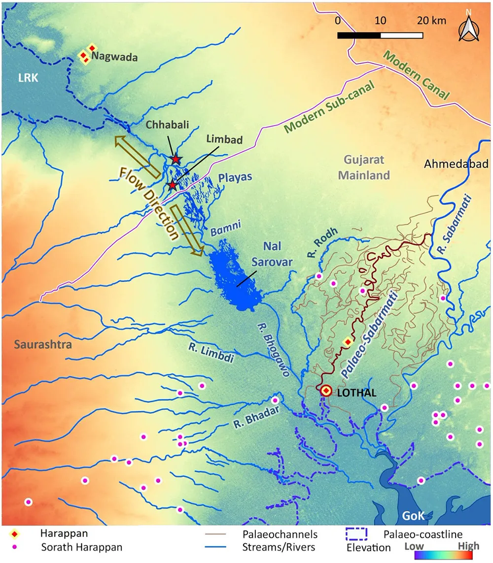
Most importantly, the paper builds its case by focusing on the Nal Corridor, a narrow, low-lying region connecting the Rann of Kachchh and the Gulf of Khambhat. During the Harappan period, this region experienced seasonal flooding, making it a key navigable route. This provided a shorter and safer alternative to long sea voyages around the hazardous Saurashtra coast. Satellite imagery, digital elevation models, and field surveys are used analyze the terrain and seasonal inundation in the corridor and assess their navigability during the Harappan period. Interestingly, whether or not we can determine how much higher the sea level was in those times, it seems likely that this was an important conduit for a significant portion of the year, enabling many towns along the way to participate in the manufacture and exchange of goods (and services, even if remains of these and largely lost). Lothal was positioned, as the authors so convincingly show with maps, to benefit from largely freshwater/seasonal pathways, and to act as an intermediary with the sea-faring trade that reached much farther towards the Arabian Gulf and Mesopotamia during ancient and later times: "Lothal, being an important intermediary, provided Harappan traders access to a range of valuable products such as copper (ore), steatite, agate-carnelian, shell, and ivory, which were not available, although in great demand in the greater Indus-Saraswati plains (Possehl 1976a, b; Rao 1979). Lothal traders possibly procured these raw materials from the hunting and gathering communities living in the Aravalli hills and along the banks of Narmada; and the fishing communities living in the coastal region of Kachchh, Saurashtra and Gujarat (Possehl 1976a, b)," (p. 3).
The authors delve deeply into the evidence, for example examining the types of boats used then and now to move goods through shallow waters; there is a whole section on the ethno-archaeology of boats in the area that bolsters their arguments. Flat-bottomed vessels, ideal for a variety of conditions, are still used throughout the region, but so are different kinds of ships one can imagine Indus-era peoples developed and adapted to most efficiently transport goods over different water surface types.
Lothal played a crucial role in linking inland areas with maritime trade routes. It seems to have sat precisely at the junction between three important waterways, with the third being the Paleo Sabarmati river that seems to have been far more formidable in previous eras than now in linking northern and southern Gujarat. With the the sea route through the Gulf of Khambhat, the riverine route via the Sabarmati River, and the inland water route through the Nal Corridor at its disposal, Lothal facilitated economic exchange across large regions. The authors concentrate on this larger, more interesting point than whether the specific "dockyard" at Lothal was actually used for boats. It probably was, but absolute proof remains elusive.
An all-round excellent article that should stimulate further thought and initiatives to explore the intricate networks that flourished during this period linking peoples and places in much richer and deeper ways than ever before.
A companion paper by the same authors, Sabarmati and its connection with the Harappan port Lothal and the Nal corridor: A study using multi-sensor data, cloud-computing and multi-platforms investigates whether this and other emerging evidence supports the theory that Lothall's famous "dock," was actually a dock or not.
Note: both articles are behind a paywall.
Images:
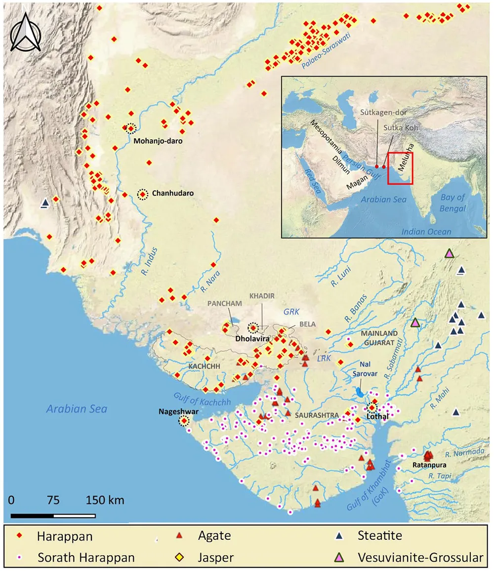
1. Study Area Map
2. Visualisation of the terrain and drainage flow around the Nal Corridor. [Palaeochannels and palaeo- coastline are sourced from Gupta and Prabhakar (forthcoming paper)]