
Often archaeology is all about digging deep, trying to get to the bottom layers on a site, intensively recording depths and detail. Sometimes it is about casting a wider net, in this case a larger area near an old bed of the Beas River in Punjab, to gather as much information as possible to draw inferences and conclusions about the smaller "rural settlements [often] . . . neglected by scholars" (p. 1) in the author's words. These settlements dotted the area to the east and southwest of Harappa. Special attention was paid to one set of sites in Tehsil Dunyapur, southeast of Multan, where the author and a team of archaeologists were literally outrunning or arriving just as modern tractors and agriculture had done their damage, relegating sites that had survived for up to 45 centuries to dust. Nonetheless, quick gathering of pottery and other sherds, even the discovery of almost intact Harappan wells or their outlines, yielded a wide variety of evidence that helps paint a better picture of the Harappan "hinterland." Much of this work was carried out in the 1990s. Decades later, this evidence was combined with results from satellite imagery of relict (ancient, now unused) channels near the old Beas river bed and locations visited by archaeologists the ground to more investigate how these widely dispersed towns and villages would have gotten water from what today (and yesterday) seem like limited resources from wells.
The result are some exemplary insights and well-argued speculations that take on larger issues of water and resource management, once again highlighting the "ingenuity" which Indus peoples brought to handling the most precious of resources (p. 2). Building on and challenging the work of others, Dr. Wright also arrives at important larger points, specifically about the political control of water.
"Our methodology," writes the author, "was based on scraping surfaces to identify remnant features in a region recently leveled for establishment of homesteads, crop farming, and animal husbandry. The article includes unpublished maps, surface records, diagnostic finds, and radiocarbon dates based on core samples. The research captures a short period when Harappans moved to parts of this region and engaged in unique forms of water management techniques. Follow up analyses and satellite imagery provide evidence for site modification and heritage loss," (p. 1).
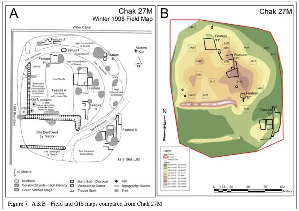
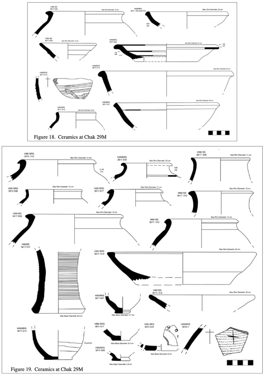
Detailed descriptions of the work carried out at a number of sites of the total of 18 surveyed is given, including the large (at least 3.5 hectare) site of Mai Manoor Bhit where a Harappan well was found at the surface, as well as evidence for five others. The variety of pottery collected on and near the surface in a day or two and compared to the large pottery stores and typologies developed during many years of excavations at Harappa is astounding; the re-imagined complete pieces including figurines testify to manifold objects from early to later Harappan times. Field maps, drawings and similar surface "excavation" techniques were used on a number of other sites, with names like Chak [Plot] 21M, Chak 27M and so on, in one case but half a kilometer from another site. Despite fresh wounds from agricultural work in many instances, as the author writes about Chak 29M [see Image 2 above] "large quantities of ceramics with a tremendous amount of variety of Harappan types are from the Early and Mature Harappan. Much like the other Beas sites at Dunyapur, there were many large bowls and tall jars with large maximum diameter width (506 for example). Both are obviously very useful for storage. On figure 18, 502 is part of a dish on stand. Similar types are illustrated on figure 19. Ledge shouldered and other large and small jars are illustrated along with string cut and contiguous bases; while 517 is unusual and may be an early Ravi/Hakra small vessel. The small fragment with the plus/or X ‘sign’ may be a potter’s mark or other message. Object bearing number 520 is a base and body part of a perforated jar, a type found at most of the Dunyapur settlements. In our pottery yard database there are many entries for Chak 29M ceramics recorded as extremely large body sherds which are labeled as unidentifiable," (p. 12-14).
Furthermore, "the Dunyapur Chaks not only shared some traits or traditions with other settlements in our survey, but also were unique. Based on the evidence from ceramics and small finds discovered at the Dunyapur settlements, newcomers to the area were in touch with Harappans beyond the region in which they settled and brought experiences and ideas with them to Dunyapur. They showed a clear interest in water and engaged in practical applications of underground sources. Viewed from the perspective known from Mohenjo- daro, the principal vantage points from which underground technologies were known was for potable drinking water, sanitation and urban maintenance. Michael Jansen titles the results of his research at Mohenjo-daro, City of Wells and Drains Devoted to an Ethos of Water Splendour (Jansen 1993). At Mohenjo-daro the wells were either assigned to a single household or shared by two or three. Small and large jars (some almost one metre tall and one metre at their maximum body diameter filled with water were located at convenient points along streets for maintenance and other uses (Wright and Garret 2018)," (p. 20).
This leads to interesting speculation based on Heather Miller's idea that the rope marks on wells at Mohenjo-daro were instances of the early use of shaduf [hand-operated device for lifting water, invented in ancient times and still used in India, Egypt, and some other countries to irrigate land] methods here too to support agricultural practices, even if on small plots and areas near the wells. The sites at Dunyapur could have used wells in similar ways to water plots for foodstuffs, which would help explain how so many settlements could have survived in an area which would have had limited water resources.
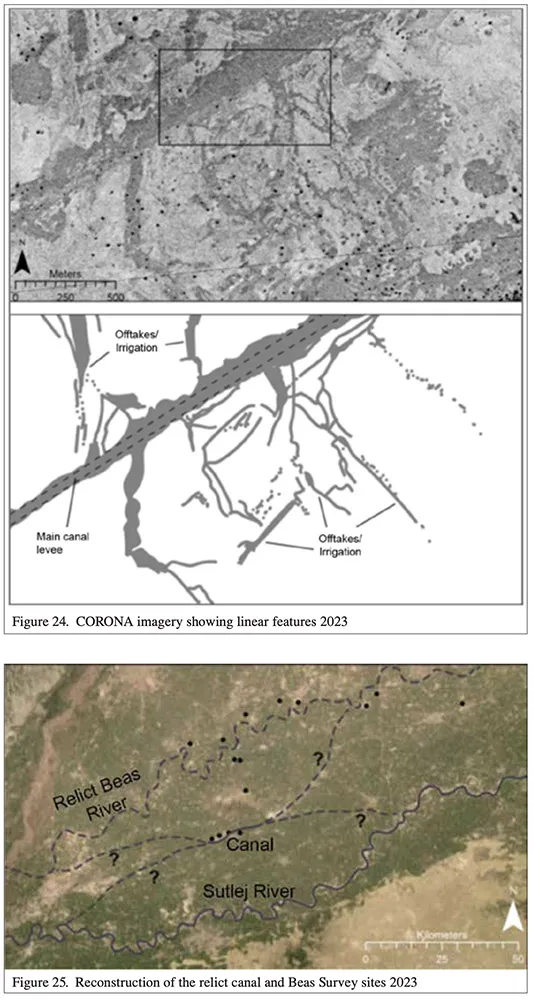
That said, a most interesting part of the paper comes at the end, when the author uses satellite imagery to consider whether the ancient Harappans constructed their own canals to transport water from old channels and beds of the Beas river [see Image 3 above]. These so called "relict" features, dried-out beds of canals, appear differently in satellite imagery, and appear to have come close to many of the Chaks investigated where ancient Indus artefacts from all periods were found. Natural channels that have since disappeared, but left traces on imagery, appear to meander as natural formations typically did. The author writes: "The remains of a canal are shown by imagery comprised of darker sediments that surround the desert plain. Numerous smaller linear features are interpreted as offtakes shown adjacent to the main canal. The linear quality of the sedimentary feature is suggestive of an anthropogenic channel that differs from the snake-like meander patterns followed by the Sutlej and the Ravi rivers. Figure 25 [ see Image 3] reconstructs the course of the relict canal identified in the Dunyapur dune field. The canal system originates and ends in either the modern Sutlej River channel or the ancient Beas. Dots indicate the locations of the Harappan sites recorded by the Beas survey," (p. 21). We cannot be sure that this apparently straight channel was made by humans, but it is not unreasonable to suspect that Indus people would have been capable of such engineering feats thousands of years before the Mughals and British similarly transformed landscapes for agricultural and economic benefit.
Finally, Dr. Wright ties up all the analysis, and evidence from other ancient Indus areas by archaeologists like Rafique Mughal (Cholistan) and Cameron Petrie (northwest India) to argue that the highly sophisticated and often different water management and resilient practices of Indus peoples in the face of ever-changing circumstances require a re-think of older archaeological constructs around water management: "A significant amount of time has passed in which to forego the theories of Karl Wittfogel (1957) who believed that political control of water management systems required despotic rule. Our studies at Dunyapur and at other Harappan villages have documented a variety of inventive water management strategies managed by Indus local farmers. Many textbooks continue to cite Wittfogel’s hypothesis despite the archaeological evidence. It’s time to set aside irrigation as a concept linked to powerful institutions (Wright 2018) and restore its meaning simply as the practice of supplying land with water so that crops and plants will grow which were undertaken under conditions Wittfogel may not have imagined," (p. 24).
An excellent article that moves seamlessly from the micro to the macro, tying together many separate pieces of theory and analysis to draw a fuller sketch of the complexity around the formation and endurance of ancient Indus civilization and their relationships to water.
Note: this paper often refers to the wider Beas Landscape and Settlement Survey first published on this site in 2015.