
It seems to be an adage around the ancient Indus research that solving one mystery simply surfaces another. This is the case with this paper. It takes on the question of ground – land – transportation in ancient Indus times only to find that larger answers around transport remain fuzzy. We know that the cart pulled by cattle or water buffalo, whose bones mark the largest assemblages of such physical body related preserved items at Indus sites [from 50-60% up to 80-90% (p. 3)], would have been a dominant means of transport for short distances. The investigation discussed here uses strontium isotope analysis that discloses where the living creatures grew up to determine how far they may have moved along trade routes. This is another example of how material analysis using new tools becoming more affordable is changing our understanding of ancient Indus times. A similar use of materials analysis by Randall Law has shown how extensive Indus raw material supply sources were, how very far away they could be from metropolises, so how were these materials transported? Rivers of course, but we are learning that rivers were also tenuous in some areas, many towns and the rural hinterland were far from rivers, and ground transport would have been a key part of a long "last mile."
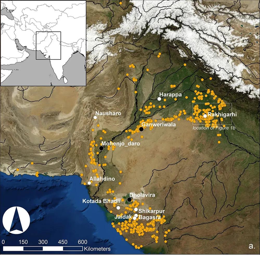
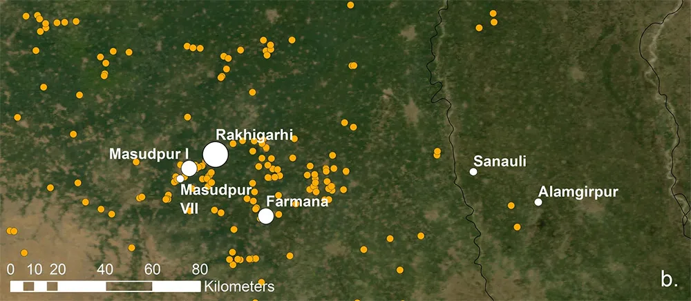
"Cattle bones reveal evidence for pathological conditions associated with the physical stress associated with traction and heavy duty labour," write the many distinguished authors from a global network of universities (p. 3). Clearly cattle were then, as now, the major labor portion of the transportation network. The water buffalo was the only real competition to Bos Indiscus. What is surprising is how separated the cattle remained from each other, staying within their region: "Animals from the sites from the plains of Haryana in northwest India presented here (Farmana, Masudpur I, Masudpur VII) are similar to each other and also to those from Rakhigarhi in terms of strontium isotope ratios. These animals are distinct from those from the site of Harappa, situated in Pakistani Punjab, in terms of strontium isotope ratios. Animals from the sites in Sindh in Pakistan (Nausharo, Allahdino) and Gujarat in India (Kotada Bhadli, Shikarpur, Bagasra, Jaidak) are distinct and also cluster together. The animals from Alamgipur presented here are clearly different to those from all of the other sites, with higher strontium isotope ratios. It is notable that the animals from the two city sites of Rakhigarhi and Harappa show a wider range overall" (p. 6). There is a wide variety of data from sites in India and Pakistan here. Alamgirpur, it turns out, is fed by a different U.P. watershed from the other sites, helping to support the value of this type of analysis.
Were goods passed on to local networks that remained rather isolated in their supply of animals? Harappa's isolation from Haryana sites per cattle transport systems is odd, they are so very close. The authors show that animals did not move long distances: "The strontium isotopic data presented here suggests that long range movement of individual animals or teams was either limited or not typical" (p. 10). The one exception, from limited data, appear to be pigs. Other perishable goods flowed freely, like fish. Did they mainly move by rivers? Navigation (upstream often too) and perennial streams would have been a big problem. "If animal-powered transport was used in long-distance movement overland, it remains unclear as to whether it occurred as part of a formalised system where individuals or teams of cattle hauling carts only travelled short distances and were replaced so that the carts and their loads could keep moving. It is entirely possible that the system was less formalised, and products were moved and then unloaded after short distances, and any movement of goods over longer distances was via a system of down-the-line or distance-decay exchange. There is clearly considerable scope for future research into and theorising about the systems of exchange and movement in the Indus River Basin. Amongst a range of possible approaches, the Indus case is ideal for exploration through network and agent based modelling that consider the distribution of individual products, their quantities and the ways in which these patterns change over time" (p. 11).
Lots more work in other words, but also more suggestions that different geographical regions were rather distinct from each other within the Indus framework. We seem to be learning that ancient Indus culture and political order was more embedded – trade, unicorn seals and uniform weights, steatite beads and walled cities, towns and outposts where exquisite craftsmanship flourished like Chanhudaro (Sindh) and Bagasra (Gujarat) – and more fragile.
A highly recommended paper. The data analysis that shows how ancient archaeology is progressing rapidly with new tooling, leading to thought-provoking points and themes well discussed.
Images: Maps of sites mentioned in the text: (1) Map of the Indus Civilization with known sites shown by orange circles, city sites by black circles and sites with animal strontium isotope data by white circles; (2) Map of the study region, with white circles indicating the sites in Haryana analysed as part of this study, where the size of the circle relates to the site size in hectares [images generated using ArcGIS and NASA Blue Marble imagery].