
One of the nice thing about archaeology is the surprises. Surprises like finding the Ghaggar-Hakra aka Sarasvati River according to some was not flowing in any big way during the Indus period (3500 BCE-1800 BCE). "It was the departure of the river, rather than its arrival that triggered the growth of Indus urban settlements there" (p. 12) conclude the authors, from a consortium of universities including IIT Kanpur. "Our OSL-derived chronologies firmly establish that a major Himalayan river was not contemporaneous with Indus settlements in the Ghaggar–Hakra region and did not sustain the Indus Civilisation in this region."
But the article does not have to undermine the riverine origins of civilizations. For one thing, during Indus times, to flourish very near massive flowing rivers like the Indus [Mohenjo-daro, Lakhanjo-daro], Sutlej, Ravi [Harappa], Jhelum and Chenab - well, that's a lot of support in the neighborhood. And even if civilizations had their origins along this riverbed, the most interesting conclusion drawn might be from Rita P. Wright, not affiliated with the study: ""As an archaeologist, when I read this, I thought, 'Oh, maybe that's why there are so many documented settlements there. Maybe they were ephemeral." In other words, people may have tracked the intermittent river flows and paths through the landscape carved by the monsoons and seasonal flows, which means they moved around a lot. We are not sure by any means, as so much more work needs to be done in the area [the largest settlement, Ganweriwala, remains unexcavated].
The study also shows, once again, that people during, before and after the Indus period have been remarkably resourceful with water and adaptable to riverine conditions and varied their crops accordingly. Its no wonder, if we look at the sanitary sophistication of the cities, but it can be hard to imagine such sophistication spreading in other ways through agricultural practices. But sophistication was present there as well. The remnants of what we see in Balochistan, on the other flank of the Indus [Mehrgarh dates to 6500 BCE], of water stored and distributed when it too was greener and more fertile – it all makes sense that there were many modes of water exploitation and settlement patterns. Cultures emerge in part to develop these resources successfully and sustainably.
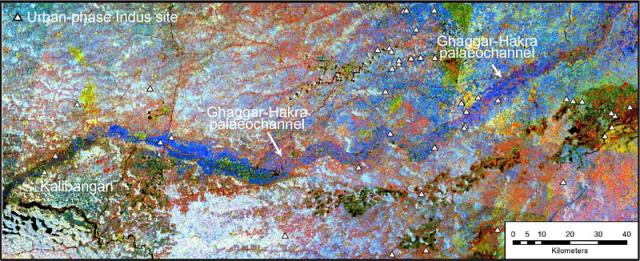
Counter-intuitive influence of Himalayan river morphodynamics on Indus Civilisation urban settlements is well-worth a read; the scientific techniques used are multiple (fluvial sediments have a lot of say); there are a dozen authors from India, UK, Denmark; and the results while dense are also beautifully illustrated in maps like the one above Corresponding TM colour composite image (detail of Fig. 2) showing correspondence of Ghaggar–Hakra palaeochannel and incised valley. Locations of urban-phase Indus settlements along Ghaggar–Hakra palaeochannel are indicated.