

Sir Alexander Cunningham (1814-1893) was the founding head of the Archaeological Survey of India [ASI] and the first person to really put Harappa on the world archaeological map.
He visited Harappa in 1853, 1856 and in 1872-73 when he carried out a small trial excavation which he discussed in the section on "Harapa" in the ASI Report for the year, which was first published until 1875. This is printed verbatim below, with attached diagrams.
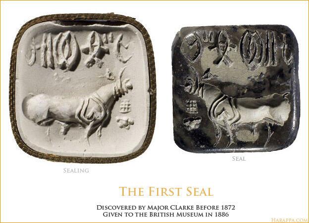
The unicorn seal he refers to (Figure 1, Image 5 above) at the end of his narrative stood out as the most mysterious of objects until his successor Sir John Marshall, following excavations at Harappa and Mohenjo-daro, was able to announce to the world that the ancient Indus Civilization had been brought to the world's attention again.
Gregory Possehl writes in Indus Age: The Beginnings that "the wanton plunder of Harappa stirred Cunningham to carry out a modest excavation there, which apparently was only a minor success. But, his report on this work includes the first site plan and his designations of the principal areas at Harappa (A-B, C, D, and E) are still used today" (pp. 49-51).
Below is the original entry from the 1872-73 ASI Report by Cunningham:
HARAPA.
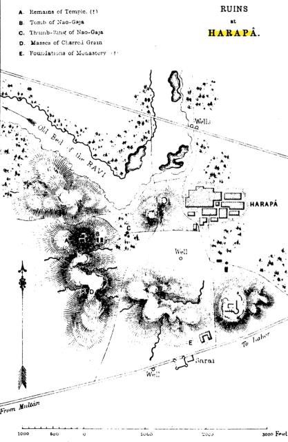
"The ruins of Harapa are the most extensive of all the old sites along the banks of the Ravi. On the north, the west, and the south, there is a continuous line of mounds about 3,500 feet in length; but on the east side, which is only 2,000 feet in length, there is a complete gap of 800 feet, for which I am unable to account. The whole circuit of the ruins is therefore about 12,500 feet, or nearly 2.5 miles.1 The highest mound is that to the north-west, which is 60 feet above the fields. On the south-west and south the mounds range from 40 to 50 feet in height, and on the north side towards the old bed of the Ravi, from 25 to 30 feet. Burnes speaks of "a ruined citadel on the river-side of the town,"2 by which I suppose he means the western side, which is the most commanding portion of the ruins. Masson calls it "a ruinous brick castle," and distinctly states that it was situated to the west, on what he erroneously supposed to be a natural rocky height 3, but which is only an accumulation of masses of brick walls and broken bricks. He describes "the walls and towers of the castle" as being "remarkably high, though, from having been long deserted, they exhibit in some parts the ravages of time and decay." I believe that Masson's visit was made in 1826 ; and just five years later, when Burnes was on his way to Lahor, the brick castle was already "ruinous." In 1853 I was informed that Mer Singh, a Sikh, had built a fort at Harapa, some 70 years ago, or about A.D.1780. Perhaps this was the castle seen by Masson and Burnes.
In 1853, and again in 1856, I traced the remains of flights of steps on both the eastern and western faces of the high mound to the north-west, as well as the basement of a large square building. Here the people say was the site of a great Hindu temple in the time of Raja Har Pal or Hara Pala. But there are no traces of any castle at the present day.
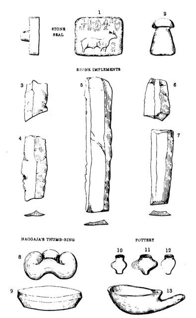
On the same mound, but lower down towards the east, there is a tomb of a Naogaja named Nur Shah, which is 46 feet long and 3.5 feet broad.4 Besides the tomb there were formerly three large stones, which the people believed to be the thumb rings of the gigantic Naogaja.5 These three stones are now on the plain below. The largest one is a black stone, 2 feet 9 inches in diameter, which is said to have been the nag, or gem of the ring. The other two are each 2 feet in diameter and 1 foot 1.5 inch high, with a hole through the middle, 10.5 inches in diameter. These are called nal and manka, and are said to be the thumb rings of the giant. They are made of yellow ochreous limestone, and are very peculiar in shape, which is difficult to describe. They may be called undulated rings of stone; but the best idea of their shape will be derived from the accompanying sketch.6
About 70 feet still lower down the eastern slope of the mound there is a small ruined Idgah, which is said to have been built in the reign of Akbar.
On the south face of the southern mound, there are the traces of a large square building with rooms on four sides surrounding a court-yard, as in a Buddhist monastery. The walls were very massive; but the whole have now been removed to form ballast for the Railway. Perhaps the best idea of the extent of the ruined brick mounds of Harapa may be formed from the fact that they have more than sufficed to furnish brick ballast for about 100 miles of the Lahore and Multan Railway.
The people refer the ruin of Harapa to the wickedness of a Raja named Har Pal, or Hara Pala, who was in the habit of claiming the sovereign's rights at every bridal. At last, in the exercise of this royal privilege, he committed incest with a near relative. Some say his own sister, others his wife's sister, or his wife's sister's daughter. The girl prayed to heaven for vengeance, and then the city of Harapa was instantly destroyed. Some say it was by fire, and some by an earthquake; others say that an invader suddenly appeared, and that the city was taken by storm, and the Raja killed. The period of its destruction is vaguely said to be 1,200 or 1,300 years ago. If the date is correct, the city of Harapa must have been destroyed by Muhammad-bin-Kasim in A. D. 713, just 1,260 years ago. I am inclined to put some faith in this belief of the people, as they tell the same story of all the ruined cities in the plains of the Panjab, as if they had all suffered at the same time from some sudden and common catastrophe, such as the overwhelming invasion of the Arabs under Muhammad-bin-Kasim. The story of the incest also be longs to the same period, as Raja Dahir of Alor is said to have married his own sister.
In another place7 I have advocated the claims of Shorkot to be identified with the city of Po-fa-to, or Po-fa-to-lo, where the Chinese pilgrim halted for two months to study the principles of the sect of Sammitiyas.8 But I have now visited Shorkot, and I have satisfied myself that it never could have reached the size of 20 li, or upwards of three miles in circuit, which the pilgrim assigns to Po-fa-to, or Po-fa-to-lo. But the size agrees almost exactly with that of Harapa,9 and as the position otherwise corresponds, I believe that Harapa must be the very city visited by the Chinese pilgrim. He describes the population as very dense. There were four stupas and twelve monasteries counting about 1,000 monks, besides twenty Brahmanical temples. Near the town there was a large ruined monastery which had been destroyed by lightning.
I am unable to offer any explanation of the name of Po-fa-to, or Po-fa-to-lo, which M. Julien has altered to Po-lo-fa-to, for the purpose of making it agree with a known Sanskrit word, parvata, or "mountain." But as Harapa is in the open plain, this reading does not commend itself for acceptance. The name of Bavanni seems to offer the best equivalent of the first two syllables Po-fa, but Bavanni could never have been even one-half the size of the Po-fa-to-lo of Hwen-Thsang.
I made several excavations at Harapa, but the whole surface had been so completely cleared out by the Railway contractors that I found very little worth preserving. My chief discovery consisted of a number of stone implements for scraping wood or leather. Several specimens of these are given in the accompanying plate.10 Most of them have one edge more obtuse than the other, with a flat surface between; but a few have the two edges alike, with a single ridge between them. They are nearly all made of a dull cream coloured stone, but a few of these are nearly black in colour.
My excavations also brought to light numerous specimens of ancient pottery, of which I have given some sketches in the accompanying plate. Fig. 22 appears to be a clay spoon or ladle.
The most curious object discovered at Harapa is a seal, belonging to Major Clark, which was found along with two small objects like chess pawns, made of a dark brown jasper. All these are shewn in the accompanying plate.11 The seal is a smooth black stone without polish. On it is engraved very deeply a bull, without hump, looking to the right, with two stars under the neck. Above the bull there is an inscription in six characters, which are quite unknown to me. They are certainly not Indian letters; and as the bull which accompanies them is without a hump, I conclude that the seal is foreign to India.
Harapa has yielded thousands of coins of the Indo-Scythians and their successors; but I am not aware of the discovery of a single Greek coin."
- Sir Alexander Cunningham, Archaeological Survey of India, Report 1872-73, Delhi, 1875.
Upinder Singh, in his book The Discovery of Ancient India Early Archaeologists and the Beginnings of Archaeology (Delhi, Permanent Black, 2004) puts Cunningham's work at Harappa into a larger context and suggests how much the lens which archaeologists bring to their work influences their interpretations:
"With all his archaeological experience and intuition, why did Cunningham not realize the enormous significance of what he had stumbled on at Harappa? Part of the reason seems to be his general pre-occupation with things Buddhist. The fact that he thought Xuan Zang had been here probably spurred him on to excavate in the first place. He did find remains of structures, very tentatively labelled by him as a temple and a monastery, but there was nothing substantial or definitely Buddhist. This encounter with the unfamiliar did not lead, curiously, to further investigation or questioning. The Harappan seal, which Cunningham described and illustrated, was a vital clue. Its significance was lost when Cunningham decided it was a foreign object on the basis of the fact that the bull depicted on it was not the typical Indian humped variety. A few years later, Cunningham had changed his mind and reached the conclusion that the writing on the seal represented an early indigenous Indian script; in fact he suggested certain similarities between its characters and Ashokan Brahmi. But he was way off the mark when he dated the writing on the Harappan seal to circa 400 BC [Cunningham 1877]. It would take another half century for the dramatic importance of the remains at Harappa to be realized." (p. 98)
Purushottam Singh, in a keynote address on Sir Alexander Cunningham in 1996 (Revealing India's Past, Aryan Books, 2005), writes, in a comprehensive summary of the early archaeologist's career:
"As regards the assessment of Cunningham's contribution to Indian archaeology, opinions are sharply divided. That he was a colossus, a familiar figure, which had been striding the Indian archaeological scene for well over a quarter of a century, is not in dispute. He had been preceded by explorers like Francis (Hamilton) Buchanan and the first archaeological survey of Scottish indigo-planter Fergusson had been completed between 1835 and 1842. Similarly, Mackenzie and Tod had been collecting antiquities for long time. At about the same time the success of the trignometrical and topographical survey from the beginning of the 19th century was also a source of inspiration. Besides, Cunningham himself had already had experience of arduous geographical explorations with which he combined field archaeology.
Cunningham's contributions can really be appreciated when we think that explorations in those days were a painful, hazardous business. Most of the travelling had to be done on horseback, but he also used elephants, bullock-carts and camels: sometimes he even travelled on foot. Perhaps the greatest contribution of Cunningham to Indian archaeology was the listing of immense number of sites all over northern India and particularly in areas hitherto unsuspected of antiquarian potentiality. Besides, he discovered and collected a large number of inscriptions and deciphered many of them, which in turn helped to illumine many a dark comer of Indian history. The same is true about coins. He was one of the greatest collectors of all times; many new types and varieties were for the first time discovered by him. He provided us with the first chronological framework for the whole series of ancient Indian coins in his prolific numismatic papers in the JASB and the Numismatic Chronicle. Further, bv identifying several ancient sites he was able to reconstruct the geography of ancient India, which he published in the form of a monograph in 1870.
"Cunningham's critics blame that his tours of exploration were only hurried visits from site to site, as in one field-season he visited as many as 30 of them. Similarly, his excavations remained a kind of test probing, which were never followed by concerted, planned attack with definite aims in view. Cunningham has also been charged that he failed to grasp the principles of stratigraphy even while excavating 50 feet high mounds. However, it seems that "car the end of his career, Cunningham had understood the principal of some sort of sratigraphy as seen in his famous Mahabodhi, published from London in 1892.
"Summing up, the true place of Cunningham in Indian archaeology, [Jean Philippe (1871-1958] Vogel has remarked 'Here, as elsewhere, the great pioneer of Indian archaeology only demarcated the field, leaving to others its further exploration'. He was indeed a pioneer and that is his greatest claim to recognition by posterity." (p. 91)
Images:
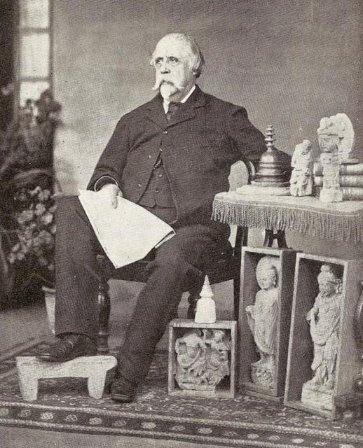
1. Major General Sir Alexander C. Cunningham, K.C.S.I., C.I.E. Late Bengal Engineers, Reprinted in Sandes, E.W.C. (1935) The Military Engineer in India. Volume II. Institution of Royal Engineers, Chatham. Source: Wikimedia.
2. Ruins of Harapa in ASI Report 1872-73.
3. Cunningham's Diagrams of items found at Harappa.
4. Later photograph of the first seal in Cunningham's diagram above, Courtesy The British Museum.
5. Frontispiece, ASI Report 1872-73.
1. See Plate XXXII [Image 3 Above].↩
2. Travels into Bokhara, III, 137.↩
3. Journeys in Beluchistan, &c, I, 452.↩
4. Burnes, by some oversight, makes this tomb only 18 feet in length.— Travels into Bokhara, III, 137.↩
5. Masson's Travels, &c, I, 452.— " I examined the remains on the height, and found two circular perforated stones." See also Barnes's Travels, III, 137.— "A large stone of a circular form and a huge black slab of a novel shape which lie near the grave, &c."↩
6. See Plate XXXIII, Figs. 6 and 7.↩
7. Ancient Geography of India, I, 203.↩
8. Julien's Hwon-Thsang, I, 210.↩
9. Burnes' Travels into Bokhara, III, 137, makes the circumference of Harapa *' about three miles."↩
10. See Plate XXXIII, Figs. 3, 4 and 5.↩
11. See Plate XXXIII, Figs. 1 and 2.↩