Maps

Ancient Indus civilization maps including sitemaps.

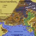
Photograph of Mound AB. There also appears to be a smaller mound that is present at the modern Harappa town site. This could be a modern representation of the processes that built ancient Harappa. This is especially noticeable since the surrounding… >

This map shows raw material distributions in the Indus Valley and adjacent regions. The extensive trade networks of the Harappan Period (2600-1900 BCE) linked distant resource areas to the major cities in the Indus and Ghaggar-Hakra river valleys. G… >

Plan view of Trench 39N Harappa phase levels with locations noted for some finds including the ring stones, terracotta beads, and sandstone beads. The baked brick drain (Feature 8) probably dates to sometime in Period 3B (ca. 2400-2200 BC), whi… >

The paleotopography represents the pre-occupation topography as it may have existed about 5000 years ago. There may be some areas in the paleotopographic model that may not represent the actual paleotopography, but rather subsequent anthropogenic in… >

This map shows the networks that connected urban centers such as Mohenjo-daro and Harappa during the Harppan Period (2600-2000 BC) with their hinterlands and distant resource areas.In addition to these two cities, other known urban centers include D… >

Plan view of the east side of Mound E and the west side of Mound ET showing areas excavated between 1993 and 2001 (Trenches 9, 10, 11). The massive perimeter wall of Mound E encloses architectural remains of Harappa phase Periods 3B and 3C and proba… >

Using maps and cross-sections of the cultural deposits from HARP, surfaces were generated to represent the interfaces of cultural layers in the mounds at Harappa. This represents the growth of the city of ancient Harappa vertically and through time… >

This map shows the major cultural interaction regions c. 1900-1300 BC: Cemetery H in the north, Jhukar in the south and Rangpur in Gujarat. During this period there were still urban centers in the Punjab and Sindh, but there was a breakdown in trade… >

Cross-sections inside (top) and outside (bottom) of perimeter wall [250]. The wall itself, being of mud-brick, was heavily eroded, sometimes to a lower elevation than the adjoining more densely packed street debris. As can be seen in the bottom cros… >