Maps

Ancient Indus civilization maps including sitemaps.

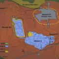
The excavation map is defined by the Harappa Archaeological Research Project, and shows the extent of occupation phases during different chronological phases. The major excavation areas featured in this presentation are Trenches 38, 39 and 42 on Mou… >

Plan view of Trench 39N Kot Diji phase levels (Period 2: 2800-2600 BC) with locations noted for major finds: sealing, elephant seal, inscribed sherds, limestone weight. This area appears to have been a street running between mud-brick structures. Ha… >

Photograph of Mound AB. There also appears to be a smaller mound that is present at the modern Harappa town site. This could be a modern representation of the processes that built ancient Harappa. This is especially noticeable since the surrounding… >

This map shows raw material distributions in the Indus Valley and adjacent regions. The extensive trade networks of the Harappan Period (2600-1900 BCE) linked distant resource areas to the major cities in the Indus and Ghaggar-Hakra river valleys. G… >

Plan view of Trench 39N Harappa phase levels with locations noted for some finds including the ring stones, terracotta beads, and sandstone beads. The baked brick drain (Feature 8) probably dates to sometime in Period 3B (ca. 2400-2200 BC), whi… >

The paleotopography represents the pre-occupation topography as it may have existed about 5000 years ago. There may be some areas in the paleotopographic model that may not represent the actual paleotopography, but rather subsequent anthropogenic in… >