Period IV-V 1900-1700 B.C. Period IIIBC 2450-1900 B.C.Period IIIA 2600-2450 B.C.Period II 2800-2600 B.C.Period I 3300-2800 B.C. Pre-Occupation before 3300 B.C. The purpose of this continuing research is to develop a system for… >
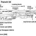
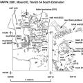
The locations of all important artifacts from Trench 54 South were carefully mapped using standard triangulation methods supplemented by printouts of digital overviews. >