
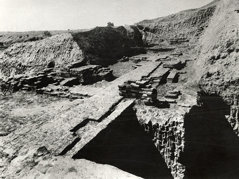
The excavations on mound A-B revealed several strata of inhabitation with walls, platforms and drains indicated. Several objects were unearthed in these strata. These two photographs show the same view, with first a wider angle of the site, and then a closer look at the brick structures. The first of these photographs was also published in Marshall's announcement of the discovery in the Illutrated London News in September 1924. These photographs would have been taken earlier that same year when Sahni had excavated these spots in Harappa.
"The operations were then shifted to the mound marked A-B in general Cunningham's plan, on the east side of which some trial diggings had been carried out in the year 1920-21. The object of this years work was to obtain a general idea of the stratification of this lofty mound before operations on a larger scale were emarked on. For this purpose a trench of about 140 feet long and 25 feet wide was drawn in continuation of the previous excavations referred to above. Two other trenches were also sunk at right angles to it towards the west. Owing to the deep accumulation of earth and insufficiency of funds the virgin soil could not be reached anywhere. A portion of the main trench was, however, carried to a depth of some 20 feet above the surrounding fields or about 35 feet below the highest point of the mound. This resulted in the determination of as many as seven successive layers of buildings indicating a very prolonged occupation of the site with, no doubt, other strata still unexposed below them....
"In the fifth stratum from the top two brick structures were observed. One of these is a square room with thick walls and paved interior which was divided into two smaller chambers at a later date. A narrow covered drain in its south wall and two low masonry benches on the inside seem to point to its having been used as some sort of an image shrine though it is difficult as yet to say whether idol worship existed in those early times. In this connection it is interesting to observe that the operations of 1920-21 brought to light at this very spot the defaced terracotta base of a statuette which might have been an object of worship. The other structure found on this level is a confused mass of brick remains in which a thick wall, thirty feet in length, resting partly on a solidly built platform stands out prominently. A small square seal of white plaster in perfect preservation (Plate XIX. fig.21) was sticking to this wall. The next lower stratum is represented by the somewhat better preserved structure which had been laid bare in this area in 1920-21 and a number of tunnels left by the brick diggers."
- Daya Ram Sahni, 1926. Annual Report Of The Archaeological Survey Of India 1923-24, pp. 53-54. Image: Plate XX, d (not referenced in text).
Excavation B
"In the northern portion of this mound (A-B), Rai Bahadur Daya Ram Sahni excavated a considerable area (B) in the years 1920-21, 1923-24 and 1924-25. He began by sinking a trial trench 55 ft long by 20 ft. wide, a little to the west of and parallel to the tomb of Naugaza. This trench was extended to a length of over 160 ft., and later on, at right angles to it, he sank two subsidiary trenches towards the west which cut across the highest portion of the mound, the northern one distinguished as D trench, and the southern one as Bg. On these being linked up the whole excavation was called B (PI. XXIX), This area is now an irregular polygon measuring some 160 ft. from east to west by 100 ft, from north to south increasing to 160 ft. along the eastern side.
From the highest point—590 ft. above the sea-level—the ground covered by this excavation falls some 20 ft. in level towards the south and east (PI XXIX, Section of Trench B), so that for a space of about 40 ft, along its eastern edge we come almost at once to the IVth stratum of remains, without encountering any of the three upper strata. On the other hand, in the middle part of this area, the IVth stratum is reached at a depth of 12 to 21 ft. below the surface. To avoid confusion on the part of the reader, a word must be said here in regard to the method of recording followed during the time of the Rai Bahadur. It appears that the depth of antiquities was then recorded sometimes from the highest point of the mound, that is to say from 590 ft. above the sea-level, and at others from the surface of the ground at the point where the find was made, which, as already mentioned, might be as much as 21 ft. lower." (Vats, pg. 137)
...
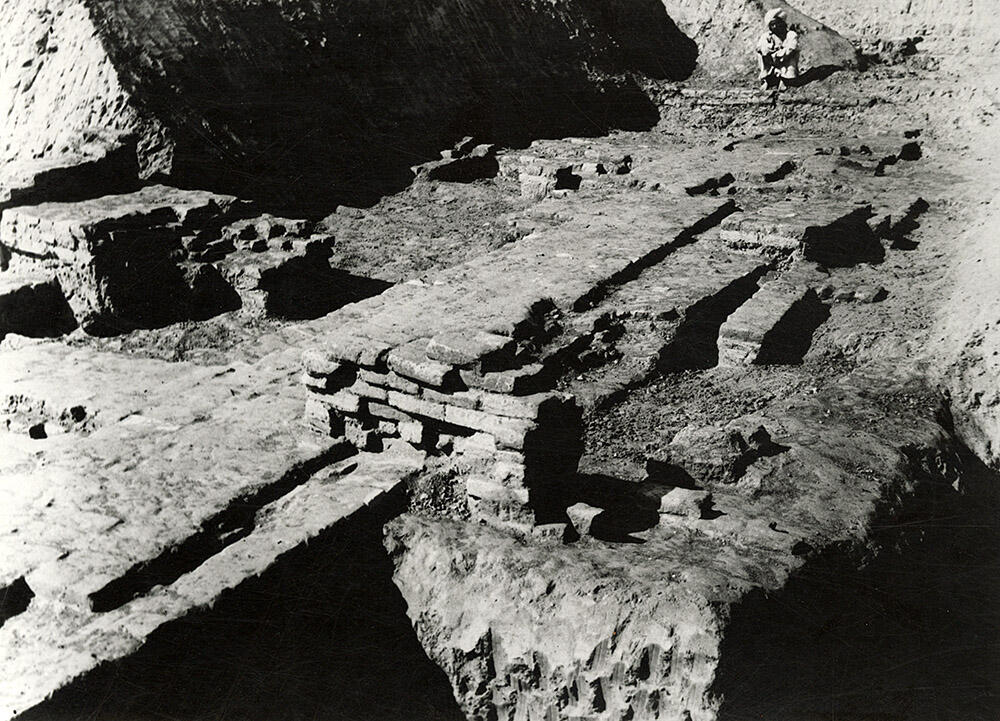
"The Vth stratum is distinguished by the massivesness of its brick structures. Along the eastern edge of the original Trench B (which was 100 ft. long from north to south and 20 to 45 ft. wide) it is clear that the buildings of the Vth stratum had been repaired and re-utilised in later times, so that there is absolutely no interval between the Vth and IVth strata (Pl XXI. a, right hand background) [This is the same as Slide 37 in our collection].
A number of tunnels sunk by brick-diggers were met with at this level, particularly towards the north, with the result that what now survives is a more or less confused mass of remains in which the layout of the walls is far from clear. Nevertheless, the Rai Bahadur notices two brick structures in the Vth stratum. “One of these”, he says, "is a square room with thick walls and paved interior which was divided into two smaller chambers at a later date." The other structure, in squares F 18/20, 25, etc., is a jumble of brick remains in which there is a thick wall some 30 ft. long from east to west to the north face of which was found sticking a small unicorn seal (5/8 in. sq., No. B230) with three pictograms (Pl. LXXXIX, 135).
In squares P 18/11 and 12 are the remains of an oblong room measuring 14 by 12 ft. internally (Pl. XXX, d, right hand, centre), but its walls are not bonded with one another. Its west wall, which is the thickest and rises from a greater depth, was originally constructed with the VIth stratum and subsequently raised. In contact with and parallel to its north wall is a slightly earlier wall which is seen projecting from below the east wall of this room. Alongside of it is a small rectangular drain built across the wall." (Vats, pp. 142-43)
- Madho Sarup Vats, Excavations at Harappa: Being an account of archaeological excavations at Harappa carried out between the years 1920-21 and 1933-34. Volume I - Text; Volume II - 139 Plates., pg 137-143. Plan Pl. XXIX; Pl. XXI; Pl. LXXXIX; Pl XXX)
This large east west wall is associated with what is called Stratum V. The photo was taken from the east looking west. This is the lower level of a larger structure that would represent a very big building. Excavations by the Harappa Archaeological Research Project in 1997 found traces of similar walls to the north of this area. See the plan of Harappa phase remains from later excavations.
- Jonathan Mark Kenoyer, 2023.