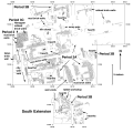
Home

Main navigation

  • home
  • slides
  • essays
  • articles
  • books
  • video
  • q & a
  • blog
Secondary menu
  • about us
    • scholars
    • privacy
    • support
    • image rights
    • credits
    • contact us
  • resources

Maps

Ancient Indus civilization maps including sitemaps.

Triangulation

The locations of all important artifacts from Trench 54 South were carefully mapped using standard triangulation methods supplemented by printouts of digital overviews. >

Map of archaeological sites in the Kanrach Valley

Map of archaeological sites in the Kanrach Valley. >

Bagasra excavation map

Gola Dhoro, Bagasra excavation map 1998. Plan of trench Eq 2, storage bins and fireplace. >

Section view of walls and platforms

North-South section plan of Harappan (Period 3) and Early Harappan (Period 2) wall remnants and mud brick platforms on the west side of Trench 54. >

Plan of Adam Buthi

Plan of Adam Buthi. >

Mound F Harappa Site Map

"Six large trenches have been sunk in this mound, viz., three to the west and three to the east of the central belt. The former comprise the Great Granary Area (Trench II) with one small Trench Ae to its south-west and two Trenches Af and Ai to its … >

Pagination

  • First page
  • Previous page
  • Page 1
  • Page 2
  • Page 3
  • Page 4
  • Page 5
© Harappa.com 1995-2026 31