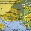
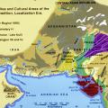
Ancient Indus civilization maps including sitemaps.
Distribution of Londo sites
Map: Distribution of Londo sites (without Makran and Iran).
Distribution of platform-house sites (Las Bela)
Map: Distribution of platform-house sites (Las Bela).
Plan of Kasota Qila Mound II
Plan of Kasota Qila Mound II.
Map of southeastern Balochistan
Map of southeastern Balochistan.
Plan of Adam Buthi
Plan of Adam Buthi.
Map of archaeological sites in the Kanrach Valley
Map of archaeological sites in the Kanrach Valley.
Satellite image of Las Bela
Satellite image of Las Bela.
Map of southeastern Iran and Pakistan
Map of southeastern Iran and Pakistan.
Structures inside perimeter wall
Excavations during the 1997-2001 seasons were carried out inside perimeter wall [250]. Here a partial plan of those excavations shows superimposed levels of Period 3C buildings, all mostly robbed of their baked brick walls.