
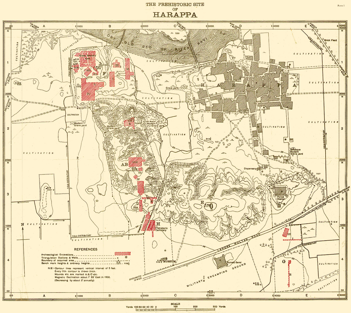
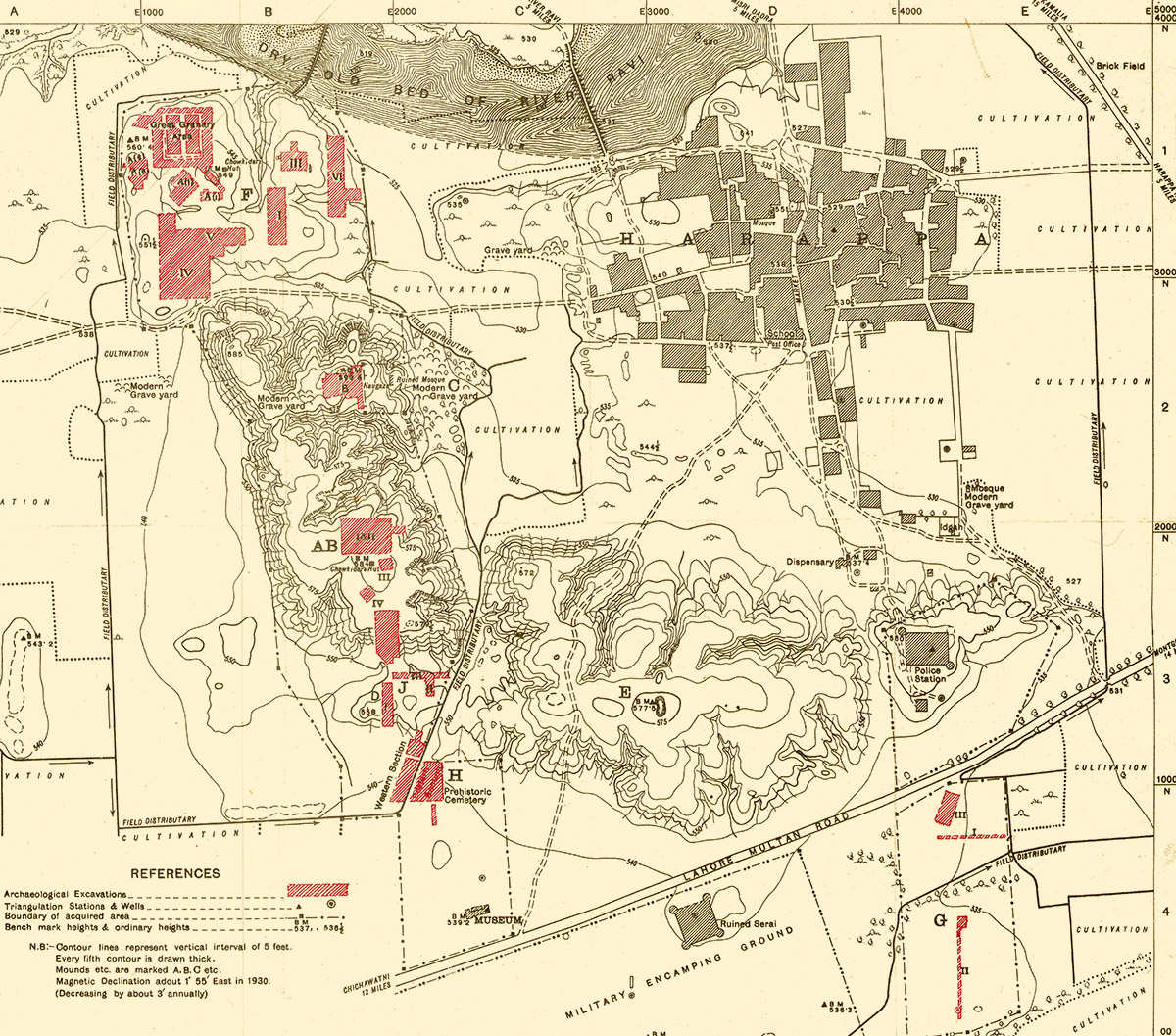
"As already stated, the principal mounds form a rough parallelogram. designated AB, E, and the one occupied by the present town are higher and larger than Mounds F, D and the Thana Mound.1 The contours2 of the town mound and of Mounds F and D do not follow each other so quickly as those of the remaining three. On the other hand, the Cemetery H and Area G, lying as they do almost on the level of surrounding fields, are hardly noticeable. How these various parts were inter-connected, one with the other, is difiicult to say since up till now excavations have been confined, principally to Mound F, and to parts of Mound AB, Areas J, G, and the Cemetery H. Nevertheless, it may be inferred that, when the valley was occupied by a continuous series of buildings there must have existed a public thoroughfare aligned, perhaps as at present, from east to west, and another one taking ofi from it and going south from between the Thana and Mound E towards Area G. At present, however, this is nothing more than a surmise. With the shrinkage and successive occupation of the mounds the level of the ancient thoroughfares has also risen. For instance, the level of the Workmen’s Quarters in the southern part of Trench IV in Mound F is lower than that of the present thoroughfare which passes along their south border, but it is possible that it might be lying on some building contemporary with the Workmen’s Quarters beneath which, again, there are the remains of four earlier strata.
"The plan of the ancient site of Harappa, which appears on PI. I [above], has been drawn on a scale of 500 ft. to an inch. The contours on it indicate a vertical rise of five feet in level and their values have been co-ordinated with sea-level as recorded at the bridge over the Lower Bari Doab Canal which flows half way between the site and the Harappa Road railway station . . ..
"To co-ordinate the entire site and to locate accurately the finds and scattered bits of surviving buildings, a comprehensive system of squaring has been found absolutely necessary. For this purpose the whole site has been divided into squares measuring one hundred feet each way, those running west to east being named A, B, C, etc., and similarly those going from north to south, 1, 2, 3, and so on. Each of these major squares has been divided, again, into twentyfive smaller squares whose numbers have been given on the plans as far as possible near tbe centre. As tbe larger squares run from north to south and from west to east it has been found convenient to number them at the south-east corner and in order to distinguish them from their own sub-squares, the boundaries of the larger ones have been drawn in bolder lines. Their nomenclature is simple. Thus, for example, squares resulting from the intersection of the one hundred feet divisions H & 13, J & 19, etc., are designated in the plans as H 13, J 19, etc., and similarly the ninth sub-squares of the above larger squares are designated as H 13/9, J 19/9, etc. Letters of the alphabet, being limited in number, are, where necessary, dulicated as AA, AB, AC, and so forth."
- Madho Sarop Vats, Excavations at Harappa, Delhi, 1940, pp. 8-9.
1. This is so called because the Thana or modem Police Station stands on it.↩
2. The contour lines indicate a vertical rise of every five feet.↩