
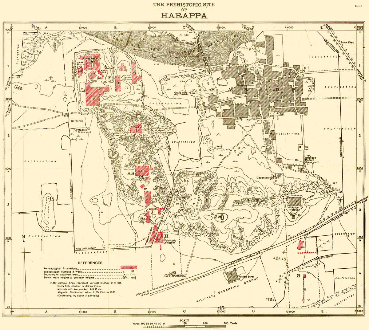
This map of Harappa was published by Madho Sarup Vats in his 1941 monograph on Harappa Excavations at Harappa: Being an account of archaeological excavations at Harappa carried out between the years 1920-21 and 1933-34. Volume I - Text; Volume II - 139 Plates. It was the very first plate in Vol II of the monograph. It gives the orientation of the site, where the mounds are, and how the trenches are laid out. We also include this earlier map at the beginning so readers can get a sense of where the early excavations in the 1923-24 season took place (sections of Mounds F and A-B), because the text that we include for the photographs constantly refers to these locations.
In terms of the significance of the 1923-24 season it is worth noting that a lot of the areas marked in red on this map would have been unknown to Daya Ram Sahni as he made his forays into Mound F and started unearthing the early structures in Trench A that was later referred to as the so-called “Granary”. Sahni then went on to excavate various structures and artefacts in Trench B.
The specifics of this plan are described by Vats in his report, and we include some salient points below:
"The plan of the ancient site of Harappa, which appears on PI. I [above], has been drawn on a scale of 500 ft. to an inch. The contours on it indicate a vertical rise of five feet in level and their values have been coordinated with sea-level as recorded at the bridge over the Lower Bari Doab Canal which flows half way between the site and the Harappa Road railway station . . ..
"To co-ordinate the entire site and to locate accurately the finds and scattered bits of surviving buildings, a comprehensive system of squaring has been found absolutely necessary. For this purpose the whole site has been divided into squares measuring one hundred feet each way, those running west to east being named A, B, C, etc., and similarly those going from north to south, 1, 2, 3, and so on. Each of these major squares has been divided, again, into twenty five smaller squares whose numbers have been given on the plans as far as possible near the centre. As the larger squares run from north to south and from west to east it has been found convenient to number them at the south-east corner and in order to distinguish them from their own sub-squares, the boundaries of the larger ones have been drawn in bolder lines. Their nomenclature is simple. Thus, for example, squares resulting from the intersection of the one hundred feet divisions H & 13, J & 19, etc., are designated in the plans as H 13, J 19, etc., and similarly the ninth sub-squares of the above larger squares are designated as H 13/9, J 19/9, etc. Letters of the alphabet, being limited in number, are, where necessary, duplicated as AA, AB, AC, and so forth."
- Madho Sarup Vats, 1940. Excavations at Harappa: Being an account of archaeological excavations at Harappa carried out between the years 1920-21 and 1933-34. Volume I - Text; Volume II - 139 Plates., pp. 8-9. Image Pl. I.