
New! This over 800 page book on the Geologic Provenience Study of Harappa's Rock and Mineral Assemblage is presented in 12 sections, each with the PDFs of entire chapters, as well as figures, images and introductory comments for each chapter.
New Introductory Paragraph by Randall Law, 2024
Presented in this section are the Table of Contents, introductory matters (Forward, Preface, Acknowledgements and Dedication) and the first three chapters of the book:
- Chapter 1 (Objective, overview and theory, Harappa and lines of inquiry) poses a set of research problems and discusses how they are to be addressed by conducting geological provenience studies of stone and artifacts from the Indus Civilization site of Harappa, Pakistan.
- Chapter 2 (Harappa in context) situates the principal research site in its geographical, geological and archaeological setting.
- Chapter 3 (Strategies and methods for sourcing stone and metal artifacts) outlines the approaches that were used to assemble a representative set of geologic samples from potential raw material sources, the different tactics, tools and instruments employed to compare artifacts from Harappa to those samples, and the various ways that the resulting data were evaluated.
---
Chapter 0: Frontmatter | Download PDF
Chapter 1: Objective, Overview and Theory, Harappa and Lines of Inquiry | Download PDF
Chapter 2: Harappa in Context | Download PDF
Chapter 3: Strategies and Methods for Sourcing Stone and Metal Artifacts | Download PDF
Occasional Paper 11: Linguistics, Archaeology and the Human Past
Inter-regional Interaction and Urbanism in the Ancient Indus Valley:
A Geologic Provenience Study of Harappa's Rock and Mineral Assemblage
by Randall William Law
Copyright Ⓒ Indus Project, Research Institute for Humanity and Nature 2011
ISBN 978-4-902325-57-7
TABLE OF CONTENTS
Foreword - Toshiki Osada. . . i
Preface - Jonathan Mark Kenoyer. . . iii
Acknowledgements . . . vii
Dedication . . . xi
CHAPTER 1 – OBJECTIVE, OVERVIEW AND THEORY, HARAPPA AND LINES OF INQUIRY ... 1
CHAPTER 2 – HARAPPA IN CONTEXT .............................................................................. 31
CHAPTER 3 – STRATEGIES AND METHODS FOR SOURCING STONE AND METAL ARTIFACTS . 49
CHAPTER 4 – THE ROCK AND MINERAL ARTIFACT ASSEMBLAGE AT HARAPPA ................... 67
CHAPTER 5 – GRINDINGSTONE ACQUISITION NETWORKS .............................................. 103
CHAPTER 6 – CHERT ACQUISITION NETWORKS .............................................................. 144
CHAPTER 7 – STEATITE ACQUISITION NETWORKS .......................................................... 178
CHAPTER 8 – AGATE ACQUISITION NETWORKS ............................................................... 262
CHAPTER 9 – VESUVIANITE-GROSSULAR ACQUISITION NETWORKS ................................. 300
CHAPTER 10 – ALABASTER ACQUISITION NETWORKS ...................................................... 325
CHAPTER 11 – LIMESTONE ACQUISITION NETWORKS ...................................................... 354
CHAPTER 12 – LEAD, SILVER AND COPPER ACQUISITION NETWORKS ............................... 396
CHAPTER 13 – SUMMARY AND DISCUSSION ..................................................................... 462
CHAPTER 14 – CONCLUDING REMARKS ........................................................................... 500
APPENDICES
REFERENCES .................................................................................................................. 749
FOREWORD
Toshiki Osada
Project leader of the Indus Project
Professor, Research Institute for Humaniaty and Nature
It is a pleasure for me to publish Dr. Randall Law’s magnum opus “Inter-regional interaction and urbanism in the ancient Indus Valley: a geologic provenience study of Harappa’s rock and mineral assemblage” as a special publication of our Occasional Paper.
I have conducted the Indus project at the Research Institute for Humanity and Nature, Kyoto since 2006. The full title of our RIHN project is “Environmental Change and the Indus Civilization”. This research project examines the social character and environmental context of the Indus civilization, and attempts to determine how they are related to the civilization’s short life and rapid decline. In particular, we aim to evaluate the impact of environmental change on the subsistence economy and trade network that sustained the Indus civilization’s urban system. We have carried an archaeological excavation at Kanmer, Gujarat and Farmana, Haryana both in India. Final reports for both excavations will be published by the end of March, 2011. The project unites a range of internationally recognized and interdisciplinary scholars. We have so far published ten volumes of Occasional Papers in which the full variety of scholars collaborating in the project presents papers as the project’s latest results.
This book is an updated version of Randall Law’s Ph.D. dissertation, which was submitted to the University of Wisconsin-Madison in 2008. He conducted the bulk of this research under the guidance of Professor Jonathan Mark Kenoyer, who is one of the most famous and active archaeologists in this field and co-director of Harappa Archaeological Research Project. Dr. Law’s intensive field work took him across an area that ranged from the Northern Areas of Pakistan to Gujarat, India in the south and from Makran coast of Balochistan in the west to the Aravalli Range Rajasthan in the east. He has recently expanded his research activities to the eastern Arabian Peninsula. Along the way he collected geologic samples of rocks and minerals used by Harappans such as steatite, chert, limestone, agate and copper. These samples were later directly compared to artifacts from Harappa using a range of methods such as X-ray diffraction analysis, electron microprobe analysis, Pb isotope analysis and neutron activation analysis. I believe Dr. Law’s research goals dovetail nicely with those of our RIHN project and, thus, I have decided to publish his work as part of our Occasional Paper series.
I hope Dr. Law will continue his original work and lead his generation in Harappan Studies.
PREFACE
Jonathan Mark Kenoyer
Professor, Department of Anthropology
University of Wisconsin-Madison
Writing a book about rocks and minerals of a long dead civilization is a daunting task, and while there are many who have taken up the challenge few have succeeded like Randall Law. Without doubt Randall’s doctoral dissertation, which is now being published in this well illustrated book, represents the most important recent contribution to the ongoing studies of the Indus Civilization. It is an outstanding example of how to develop new strategies to study old problems, and how to squeeze blood from old rocks and make a dead civilization live again. The old problems that have been examined in this book relate to the origin and development of the Indus Civilization (2600-1900 BC), an urban society that emerged in the vast plains of the ancient Indus and Ghaggar-Hakra-Saraswati Rivers. The “blood” or information that Randall has extracted from the study of rocks and minerals has been used to test long held models on the development of inter and intra-regional exchange and its role in the emergence of Indus urban centers. The results of his studies have brought to life a whole new set of interaction networks that connected Indus cities such as Harappa, to other Indus settlements and regional resource areas.
I met Randall Law at a lecture I gave as part of a panel at the Anthropological Association of America. Annual meetings in San Francisco in November 1996. The lecture was titled “Urban Development and Craft Production at Harappa, 3300-1700 B. C.” and included discussion of pottery making, lithics and stone bead production at Harappa. After the lecture we had a chance to talk about his interests in studying the archaeology and trade networks of Western China and Central Asia. Although he was not focused on the Indus I pointed out to him that there were possible connections between the Indus and Western China and that he might want to expand his research in this area. When he came to Madison to start graduate studies with me, he had recently spent several months in China and was hoping to carry out his dissertation research somewhere in Xingjiang. However, over the course of his graduate studies, and after working with me in the study of rocks and minerals from the site of Harappa, he decided to shift his focus to the Indus. This shift would still allow him to explore the regions to the north of Harappa, including northern Afghanistan and parts of Central Asia. Based on the success that he has had in these studies, I am confident that he will eventually extend his explorations to the area of his original interest, Western China, in the coming years. I was thrilled with Randall’s decision to work at Harappa, and although I had already begun collecting comparative samples of rocks and minerals from many parts of Pakistan and India, I knew that I would not have time to exhaustively collect samples from all of the potential source areas. Because of his strong science background and his passion for geology and geography I knew that he would go far beyond anything that I had ever done. Over the course of his dissertation studies it became quite clear that he had a special gift for searching out rock sources and collecting samples from obscure regions. He also had the ability to write successful applications for funding to undertake both field research and laboratory analysis. His ability to understand complex archaeometric issues in the analysis of raw materials ensured that he used the best possible methods for sourcing various types of rocks. Furthermore, his engaging discussions and the fact that he was willing to spend generous amounts of his time helping others, opened up the doors and comparative collections of major institutions and local scholars, as well as guidance of enthusiastic villagers in all regions of Pakistan and India. I was fortunate to be able to share in the excitement as he began to collect samples and visit different source areas. In the summer of 2000 we took a road trip from Harappa to Skardu to collect rock samples for his dissertation and he loaded so many rock samples into the Harappa Toyota Corolla that it broke the rear springs. It was important to collect all of these rocks, and because of his extraordinary efforts, he has been able to obtain an unparalleled set of original samples of rocks and minerals from almost every possible source area surrounding the Indus and Ghaggar-Hakra-Saraswati River plains.
Randall’s multi-disciplinary approach to the investigation of early urbanism combines geology and scientific materials analysis, with state of the art archaeological excavations of a complex urban center. The primary archaeological data set is from the renewed excavations at the site of Harappa, Pakistan, begun by Dr. George F. Dales and me in 1986 (Dales 1989), and continuing up to the present as the Harappa Archaeological Research Project (Meadow 1991, Meadow and Kenoyer 2008). The overall goal of the project has been to understand the origin and development of Harappa as one of the major urban centers of the Indus Civilization (Dales and Kenoyer 1991). Many different strategies were developed to examine all aspects of the site. One important approach was to collect samples of raw materials, specifically rocks and minerals, from all excavation areas so that in the future, a dedicated scholar, in this case Randall Law, would be able to carefully study each and every fragment to reconstruct the trade and exchange networks that brought these materials to the site. This book begins with a well-articulated introduction that outlines the overall objectives and the theoretical frameworks being used, as well as the various methodologies needed to address specific questions. He has done an excellent job in developing an engaging writing style that tells the story of a rock, its discovery and analysis, and its overall importance to his research questions, while at the same time presenting details that will be of interest to specialists. Over the course of his dissertation research, he employed multiple complementary analytical techniques to carry out analyses of more than 3000 archaeological and modern geological samples. With the results from these studies he was able to compile for the first time, a detailed provenience map for the archaeological rock and mineral samples from Harappa and several other contemporaneous sites. He has also been able to convincingly demonstrate that only a limited number of source areas can be linked to specific raw materials from Harappa. This critical use of scientific data has allowed him to generate maps of potential source areas that would have supplied Harappa with specific raw materials during different occupational phases, (circa 3500-1700 BC). He has intentionally kept his conclusions conservative, because there are always more sources that need to be sampled, and the widespread extent or internal variation in some geological deposits are often too large to allow pin-point accuracy for sourcing. Nevertheless, the conclusions that he does reach are extremely important and serve to address two of his primary lines of inquiry regarding changing inter-regional interaction/acquisition patterns, and variations in the acquisition and use of raw materials at Harappa itself. One of the most important discoveries has been the fact that many of the important raw materials used for creating both utilitarian and prestige goods came to Harappa from sources located far to the north in the mountainous regions of the northern Indus valley. At most of these source areas there is no evidence for the presence of Harappans or in some cases there are no reported prehistoric sites at all. This has made it difficult to answer one of his other research question regarding the identification of specific communities that were providing raw materials to the Harappan cities. Clearly more research needs to be done on this topic but due to the current security situation in these regions, such studies will need to be undertaken in the future.
It is highly unlikely that any one person in the near future, will be able to collect the vast range of materials that he has accumulated and undertake a comparative study of this scale. I want to thank Randall for this stimulating presentation of a complex set of data that will take many more years to fully appreciate. Every time I prepare a lecture or write a new article, I am able to include new updates and insights based on his innovative research. This book and its extensive appendices will be a major reference for any future studies of the Indus region and beyond, not only for rocks and minerals, but all aspects of regional and extra-regional interaction. In conclusion I also want to commend the publishers and editors of this series, Dr. Toshiki Osada and Dr. Akinori Uesugi, for selecting this outstanding piece of research for their publication series. I am honored to have been able to contribute to various aspects of this project and look forward to many more years of productive
collaboration.
REFERENCES
Dales, G. F. (1989) Harappa: A New Look at the Type Site of the Indus Civilization. In Old Problems and New Perspectives in the Archaeology of South Asia, edited by J. M. Kenoyer. Madison, WI, Wisconsin Archaeological Reports. 2: 127-132.
Dales, G. F. and J. M. Kenoyer (1991) Summaries of Five Seasons of Research at Harappa (District Sahiwal, Punjab, Pakistan) 1986- 1990. In Harappa Excavations 1986-1990, edited by R. H. Meadow. Madison, Prehistory Press: 185-262.
Meadow, R.H. ed. (1991) Harappa Excavations 1986-1990: A Multidisciplinary Approach to Third Millennium Urbanism. Monographs in World Archaeology, 3. Madison, WI, Prehistory Press.
Meadow, R. H. and J. M. Kenoyer (2008) Harappa Excavations 1998-1999: New Evidence for the Development and Manifestation of the Harappan Phenomenon. In South Asian Archaeology 1999, edited by E. M. Raven. Leiden, International Institute of Asian Studies: 85-109.
ACKNOWLEDGEMENTS
I am indebted to numerous individuals and institutions around the world. However, I wish to foremost thank Dr. Jonathan Mark Kenoyer – my colleague, advisor, teacher, friend, guide and guru in Madison, at Harappa and across South Asia. Studying, excavating, traveling and just hanging out with Mark for the past twelve years has been a wonderful, life-enriching experience. Shukria ji.
This book is an updated version of my PhD dissertation, which I defended at the Department of Anthropology, University of Wisconsin-Madison in May of 2008. I am deeply grateful to Prof. Toshiki Osada and to the Research Institute for Humanity and Nature (RIHN), Kyoto for agreeing to publish it and for sponsoring my August 2010 stay at the institute in order to complete the revisions. I am likewise grateful to Dr. Akinori Uesugi at the RIHN, for giving up his valuable time in order to format the final text and illustrations. Thanks also to Dr. Steve Weber, Dr. Marco Madella, Endo Hitoshi and Takeru Sonoda for their friendship, advice and assistance during my stay in Kyoto. I wish to express my heartfelt gratitude to Prof. Asko Parpola. It was his encouragement at the January 2010 RIHN-sponsored roundtable in Bhuj, India, that prompted me to pursue publishing my dissertation in this form.
Special thanks are due to the members of my dissertation committee – Drs. J. Mark Kenoyer, T. Douglas Price, Jason Yaeger, Sissel Schroeder, Nick Cahill and James H. Burton – for agreeing to read my beast of a thesis over a short span of time, several years after I first promised to deliver it. I am particularly grateful to Dr. Price who, as the Director of the Laboratory for Archaeological Chemistry (LARCH) at the University of Wisconsin Madison, generously provided access to the instrumentation on which a great deal of the data presented here were produced. And I wish to both thank and blame Dr. Burton, the associate-director of the LARCH. It seemed that every time I walked into Jim's office or the lab I came away inspired and brimming with ideas for new studies that I had to undertake (was absolutely convinced were imperative) for this research project. It literally added years to
the production my dissertation. It was completely worth it.
I am grateful to all the members of the Harappa Archaeological Research Project (HARP) but most especially to the project directors Drs. Richard Meadow and J. Mark Kenoyer for inviting me to come to the site, teaching me to excavate there and allowing me to study the materials that they and others had labored many seasons to recover. Many thanks also to Drs. Rita Wright, Steve Weber, William Belcher, Heather Miller, Sharri Clark, Brad Chase, Mark Smith, Rae Beaubian, Mr. Nadeem Ghouri (and his wonderful family in Lahore) and all of the camp staff, site workmen and various friends of the HARP.
I will always be indebted to Dr. Fazal Dad Kakar, Director-General, Department of Archaeology and Museums Government of Pakistan, and the former DG, Saeed-ur-Rehman for allowing me to examine and analyze the stone and metal artifacts from Harappa and other sites across Pakistan. I am likewise grateful to department officers Saleem-ul-Haq, M. Afzal Khan, Shabaz Khan and Asim Dogar. Thanks also to Dr. Farzand Massih, former curator of the Harappa Museum who is now at the Department of Archaeology, Punjab University. And I would be remiss if I did not recognize the friendship and very good advice provided by Drs. Asma Ibrahim and Kaleem Lashari.
Dr. Ihsan Ali – formerly at the Department of Archaeology, University of Peshawar and now Vice Chancellor at Abdul Wali Khan University, Mardan has helped me in countless ways beginning long before he was my 2000-2001 Fulbright Fellowship co-advisor in Pakistan. Thanks also to the other Department of Archaeology faculty members at University of Peshawar – especially Farooq Swati, Taj Ali, Muktar Durrani, Gul Rahim Khan, Nidaullah Sehrai and Shah Nasir Khan. They made my stay in Khyber-Pakhtoonkhwa Province (then the NWFP) extremely educational and productive. The late Prof. Farzand Durrani was also a great source of inspiration while I was in Peshawar.
I am grateful to Dr. Nilofer Shaikh for her tremendous generosity during my visits to Shah Abdul Latif University, Khairpur and to the faculty there – especially Dr. Qasid Mallah (my Wisconsin class fellow), Gulam Mustafa Shar for helping me to obtain samples for this study and G.M. Vessar for guiding me through the Rohri Hills and Thar Desert.
Thanks to Dr. Javed Hussain and Professor Nargis Rashid for making me feel welcome at the General History Department, University of Karachi. With the help of former U of K students Sulaiman Ahmad, Sajid Hussain and Javaid Iqbal, I was able to undertake a highly productive field excursion through southern Sindh.
I am grateful to Farid Khan of the Bannu Archaeological Project for inviting to visit the archaeological sites of that region and to search the local riverbeds for chert samples. Thanks also to BAP members – Drs. Ken Thomas, Robert Knox, Cameron Petrie and Justin Morris.
During my 2000-2001 Fulbright-IIE and American Institute of Pakistan Studies (AIPS) funded research, I received outstanding support from then Executive-Director of the United States Educational Foundation in Pakistan Dr. Robert Lawrence and his staff led by Mr. Mazhar Awan, as well as from Nadeem Akbar and Ghulam Rasool at the AIPS’s Islamabad Center. I also received much excellent advice from the AIPS’s scholar-in-residence at that time, Dr. Michael Meister (University of Pennsylvania). And I will always remember the hospitality shown to me by the late Dr. A.H. Dani during this period both at his home and at Quaid-i-Azam University.
I am forever indebted to Azra and Peter Meadows of the University of Glasgow for inviting me to join them on their 2001 expedition along the Makran coast of Pakistan. What an amazing journey that was!
I wish to thank numerous members of the Archaeological Survey of India (ASI), but foremost the current Director-General, Dr. Gautam Sengupta, and former DGs, Mr. K.N. Srivastava and Mrs. Anshu Vaish, for their past and continued support. When he was the Joint Director-General of the ASI, Dr. R.S. Bisht always took time out of his busy schedule to provide me with excellent advice and instruction. Although retired, he remains a most valued teacher and has generously lent his support to my ongoing study of stone and metal artifacts from his excavations Dholavira. I am also extremely grateful to Dr. R.S. Fonia (Director - National Mission) for his longstanding support and guidance of my research in India. I thank Dr. Amarendra Nath for supporting my ongoing examination of materials from his excavations at Rakhigarhi. I count V.N. Prabhakar and Tejas Garge among my closest friends and colleagues in India or, for that matter, anywhere else. I would also like to recognize K.C. Nariyal, Nayan and Sangita Chakraborty, Manoj Saxena, Navratna Pathak and Manoj Joshi, each of whom has helped me in important ways.
Drs. Kuldeep Bhan, P. Ajithprasad, K. Krishnan and Ambika Patel of the Department of Archaeology, Maharaja Sayajirao University (MSU), Vadodara generously allowed me to examine artifacts from their department's many excavations and even provided several important samples for this study. Dr. Bhan, his students Kishore Ragubhans and Arun Malik (now both with the ASI), and department staff member Rajesh Brahmbhatt variously guided me on sampling trips in parts of Rajasthan and Gujarat.
I thank Dr. Jeewan S. Kharakwal and his group of exceptional students from the Department of Archaeology, Institute of Rajasthan Studies, Udaipur for hosting me at their Kanmer excavation and for allowing me to examine stone and metal artifacts from that site.
Dr. Rakesh Tewari, Director, U.P. State Archaeological Department, generously allowed me to examine the stone beads from his excavations at Lahuradewa in Uttar Pradesh. This has provided many new insights into raw material use and possible ancient trade connections with the Gangetic Basin region.
K.N. Dikshit and the late S.P. Gupta at the Indian Archaeological Society in New Delhi always made me feel most welcome during my many visits there. I deeply regret that Gupta-ji did not live to see the publication of this book.
In France, I wish to thank Dr. Jean-François Jarrige, Catherine Jarrige and Jérôme Haquet at Musée national des Arts asiatiques-Guimet, Paris. Their friendship and generosity in providing samples from Mehrgarh, Nausharo and Mundigak has greatly enriched this research project.
In Germany, I wish to thank Dr. Ute Franke (Freien Universität, Berlin) for sharing information on her various excavations in Balochistan as well as Prof. Paul Yule (Ruprecht-Karls-Universität, Heidelberg) for providing details on his documentation of silver artifacts from Sohr Damb.
In Italy, many thanks are due to Professor Maurizio Tosi (Università di Bologna) and Dr. Massimo Vidale (Instituto italiano per l'africa el'oriente) for supplementing this study with artifacts from the site of Shahr-i-Sokhta in Iran, several sites in Pakistan and a few key geologic samples. Thanks also to Dr. Maurizio Cattani (Università di Bologna) who, along with Prof. Tosi, have helped extend my research horizons across the Arabian Sea to Oman. And I will always be honored and grateful to Dennys Frenez (Università di Bologna) and Prof. Tosi for inviting me to join their Lothal Revisitation Project.
I thank my many friends in the geological sciences for their tremendous help and genuine interest in this project. In Pakistan, I foremost acknowledge the late Dr. Syed Hamidullah (see dedication) of the Centre of Excellence in Geology, University Peshawar as well as present and former members of the Centre such as Drs. Qasim Jan, Irshad Ahmed and Noor Jehan; Dr. Syed R.H. Baqri of the Pakistan Museum of Natural History, with whom I spent the single most productive month (November 2000) of geologic fieldwork I think that I shall ever experience; Drs. Mehrab Khan and Khalid Mahmood of the Centre of Excellence in Mineralogy, University of Balochistan, who generously provided access to materials in their vast collections as well as personally guided me through central and northern Balochistan; Khawar Akbar of the Geological Survey of Pakistan (GSP) – Karachi who took me through southern Balochistan; Asif Rana, Syed Ghani, M. Sadiq Maklani and Dr. Wazir Khan at the GSP – Quetta; and to Mian Sayed Badshah, Ihsan Afridi and Ahmad Ali Shah of the Federally Administered Tribal Areas Development Corporation (FATADC) for arranging my field excursions through the Waziristan and Kurram agencies.
In India, I would foremost like to thank Dr. Rajesh Sharma at the Wadia Institute for Himalayan Geology, Dehra Dun for providing much guidance as well as many samples. Thanks also to Dr. Manoj Pandit, Department of Geology, University of Rajasthan-Jaipur; Ajay Kumal, Geological Survey of India (GSI) – Jammu; N.L. Sharma, GSI – Chandigarh; and N.K. Sood, GSI – Jaipur; and Dr. K.C. Tiwari of the Department of Geology, MSU, Vadodara for his good advice and Amit Sharma (MSU Geology graduate) for his assistance in locating and sampling various material sources in Kutch and Panchmahals, Gujarat.
Back home in Madison, I would like to thank all of the Department of Anthropology Indus-walas, particularly my traveling companions in South Asia Dr. Brad Chase, Katie Lindstrom and Gregg Jamison, as well as Brett Hoffman, Mary Davis, and Alison Carter, who I’ve sometimes cajoled into undertaking aspects of this project with me. I would especially like to recognize and thank the scientists in other UW departments that have helped me turn thousands of bits of stone and metal into useful data, specifically, Robert Agasie and Kevin Austin at the University of Wisconsin’s Nuclear Reactor Laboratory, Engineering Physics Department; Dr. John Fournelle in the Electron Microprobe Lab, Department of Geoscience; and Drs. Huifang Xu and Hiromi Konishi in the S.W. Bailey X-ray Diffraction Laboratory, Department of Geoscience.
Dr. Monica Smith at the University of California–Los Angeles has been a source of academic inspiration to me and has provided much excellent advice and constructive criticism. I have come to realize that I owe a huge debt of gratitude to Prof. Gregory Possehl at the University of Pennsylvania for supporting my research through the approval of multiple fellowships and grant applications that came to him for review. I will always appreciate Greg's former students at Penn – Drs. Chris Thornton, Uzma Rizvi, and Theresa Raczek – as well as Dr. Marta Ameri, Megan McCormick and Heidi Miller for their friendship, insights and willingness to share information, data and sometimes even samples!
A word of thanks is due my undergraduate advisors at Humboldt State University – Professors Llyn
Smith (Anthropology) and Paul Blank (Geography), as well as Tony Rossi (Lecturer, Geography). I can honestly say that seeds of this research project were sown in their classrooms way back in the last decade of the 20th Century.
All errors or oversights contained herein are mine and mine alone.
Financial support for various aspects of this research was generously provided by the Harappa
Archaeological Research Project, the America Institute of Pakistan Studies, Fulbright-IIE, the George Franklin Dales Foundation, the Graduate School of the University of Wisconsin, the US Department of Energy Reactor Sharing Program, the Wenner-Gren Foundation (Gr. 7066) and the National Science Foundation (BCS-0327246).
Last but not least, I would like to thank my parents Douglas and Sue Ellen Law, my wife Veronica and my sons Alexander and Diego for their love, encouragement and support.
Prof. Dr. Syed Hamidullah, Director – National Centre of Excellence in Geology, University of Peshawar, was to have been featured prominently in my acknowledgments section to this book. Besides being a great friend and teacher, he was instrumental in helping me to secure the necessary permissions to do field research in some of the more restricted and difficult to reach parts of Pakistan. Without his guidance and support I would not have learned and I could not have accomplished even one half of what I did.
On October 15th 2005, Prof. Hamidullah died in a helicopter crash while taking part in relief efforts for the victims of the October 8th 2005 earthquake in northern Pakistan.
This book is dedicated to him.
Image: Prof. Dr. Syed Hamidullah, near Jamrud, NWFP, December 2000
****************************
Chapter 1: OBJECTIVE, OVERVIEW AND THEORY, HARAPPA AND LINES OF INQUIRY
Chapter introduction: The Principal Research Objective
This study is an examination of inter-regional interaction and urbanism in the Greater Indus region1) of Pakistan and northwestern India from the mid-fourth through the early second millennium BC - a period that encompassed the development, existence and decline of South Asia’s first urbanized society, the Indus Civilization (ca. 2600 to 1900 BC). The principal research objective is to identify the sources (geologic provenience) of rock and mineral (stone and metal) artifacts excavated at Harappa, which is a site that grew from a small village to become one of the largest Indus Civilization cities. Provenience determinations are used to address three lines of inquiry into the inter-regional and intra-site socio-economic relationships of those who dwelled at Harappa during different periods in its history:
1) Who in the Greater Indus region or beyond were the residents of Harappa interacting with when they acquired rock and mineral resources?
2) How did inter-regional interaction/acquisition patterns change over time?
3) Did synchronic variations in rock and mineral resource acquisition and use exist between groups of people living in different habitation areas at Harappa?
Underlying this study is the simple premise that rocks and minerals, from the prestige materials used to create items that signified wealth and social status to the utilitarian materials necessary to carry out day- to-day tasks, were integral to the development and functioning of early urbanized societies. The need to acquire these vital resources would have been a major impetus for interaction between the first city- dwellers of the Indus Valley, which is a region where stone and metal sources are scarce or absent, and peoples of the neighboring highlands where they occur. Moreover, power garnered from the control of such resources would have been a significant factor in promoting and maintaining the social and political stratification characteristic of an urbanized society like the Indus Civilization. Elucidating rock and mineral acquisition networks through provenience studies of stone and metal artifacts is also an excellent method with which to examine the broad-scale communication and exchange phenomena that Joseph Caldwell conceptualized (1964) as interaction spheres (also called interaction systems – Shaffer 1992: 442). Archaeologists have come to regard this form of inter- societal contact as an important stimulus for socio- cultural change and innovation (Schortman 1989: 52; Trigger 1989: 330-337). The current state of research indicates that urban lifeways in northwestern South Asia emerged in a milieu of regionally distinct cultures that maintained contact with one another through extensive trade networks and seasonal migration regimes (Kenoyer 1991a; Mughal 1990; Possehl 1990; Shaffer 1992). The resultant urbanized society was characterized by a complex series of internal interaction systems (Kenoyer 1995b), some of which articulated externally with other complex interaction spheres outside of the Greater Indus region (Edens 1993; Hiebert 1995; Lamberg-Karlovsky and Tosi 1973; R.P. Wright 1984). It has been proposed (Possehl 2002, 2007) that the Indus Civilization was part of an even larger, trans-regional system – the “Middle Asian Interaction Sphere,” which connected societies from Mesopotamia to the Indus Valley during the third millennium BC. These varying spheres of interaction and the emergence of urbanism in the Greater Indus region are examined here through a series of both broad and fine-scale geologic provenience studies of Harappa’s rock and mineral artifact assemblage.
In order to address three lines of inquiry outlined above, the entire assemblage of stone and metal artifacts recovered by the Harappa Archaeological Research Project since 1986 was categorized, periodized and quantified. Nearly 3000 of those artifacts representing eight different rock or mineral varieties were directly compared to geologic samples collected from potential source formations located across the Greater Indus region. Comparative methods ranged from examinations of basic macroscopic and mineralogical attributes to highly precise and accurate isotopic and elemental assays. In the end, provenience determinations for over 2100 stone or metal artifacts were generated.
The large body of new data produced for this study has permitted the testing of numerous hitherto untested assumptions regarding where it was that Indus Civilization peoples, their Early Harappan predecessors and their Late Harappan successors, acquired rock and mineral resources, who they were interacting with as a consequence and how such resources were distributed in an urban setting. Many findings corroborate widely held views of resource acquisition and inter-regional interaction during the late-prehistoric period in northwestern South Asia. Other findings, however, require that certain assumptions be revised. For instance, multiple lines of evidence now point to the existence of early and enduring acquisition networks between Harappa and source areas to the north of the Indus Valley, which suggest that relations with the peoples of that region were more significant than was generally supposed. Synchronic spatial examinations of Harappa’s assemblage were also revealing. It appears that, by and large, residents of all parts of the settlement had access to the same varieties of raw materials from the same sources. However, a few variations are evident that suggest groups in some areas of the site may have, at times, favored materials from certain sources and/or controlled specific kinds of stone. Finally, it has been determined that, during every period at Harappa, some rocks and minerals were derived from sources outside of the Greater Indus region, thus indicating that external trade was an important and continuous aspect of the socio-economic lives of the site’s residents. Most of those external sources were located in neighboring highland areas, however. Evidence for external trade with distant regions such as Arabia and Mesopotamia remains, at least in terms of the stone and metal artifact assemblage at Harappa, elusive.
Although the primary focus of this book is Harappa’s rock and mineral assemblage and the urban phenomenon at that site, the data generated are pertinent to the broader issue of inter-regional interaction and its relationship to the initial manifestation of urbanized society in South Asia. In order to bolster a broad-scale perspective, this study has been supplemented with geologic provenience analyses of select stone and metal artifacts from over a dozen additional prehistoric sites in Pakistan, India, Afghanistan and Iran. These data, although limited, have revealed (or confirmed) the existence of several broad-scale inter-regional resource acquisition networks as well as more localized regional ones.
In this chapter, I first provide an overview of the Indus Civilization. The theoretical orientation from which the issues examined in this book are approached is then laid out in discussions of urbanism and its preconditions, inter-regional interaction, long-distance trade and the control of essential resources, the importance of rock and mineral resources to urbanized societies and the utility of geologic provenience studies in research of this kind.
The physical and cultural/chronological aspects of Harappa are then presented. Lastly, the three lines of inquiry are reviewed and an outline is provided.
The rest of Chapter 1 is in the attached PDF below.
Images
Figure 1.1 Select Old World Civilizations (ca. 2350 BC) and sites mentioned in Chapter 1.
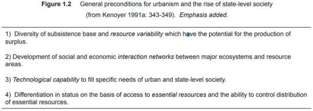
Figure 1.2 General preconditions for urbanism and the rise of state-level society
(from Kenoyer 1991a: 343-349). Emphasis added.
Figure 1.3 Harappa’s location today (world map adapted from Wandrey and Law 1998).
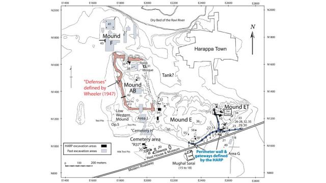
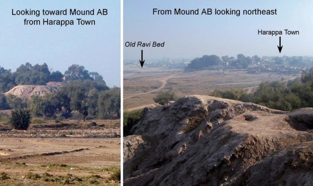
Figure 1.4 Harappa – site plan and views toward and from the mounds. This and all subsequent site plans in the dissertation are modified from Meadow et al. 2001: Figure 2.
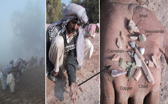
Figure 1.5 Surface survey on Mound E and some of the stone and metal artifacts recovered.
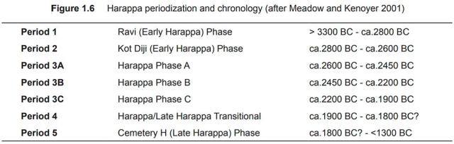
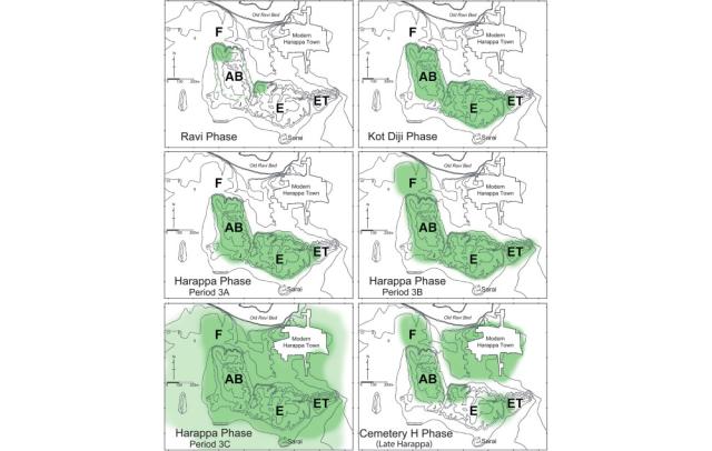
Figure 1.6 Harappa periodization and chronology (after Meadow and Kenoyer 2001)
Figure 1.7 Settlement growth and decline at Harappa ca. 3300 to <1300 BC
The Chapter section titles are:
Indus Civilization overview and theoretical orientation
The Indus Civilization
Urbanism and its preconditions
Inter-regional interaction, long-distance trade and the control of essential resources
Rock and mineral artifacts and geologic provenience analysis
Harappa
General location and layout
History of discovery and research
Harappa’s rock and mineral artifact assemblage
Harappa’s chronological / cultural sequence
Ravi Phase – Period 1 (> 3300 BC - ca.2800 BC)
Kot Diji Phase – Period 2 (ca.2800 BC to 2600 BC)
Harappa Phase – Period 3 (2600 BC to 1900 BC)
Period 3A
Period 3B
Period 3C
Transitional and Late Harappa Phases – Periods 4 & 5 (1900 BC to <1300 BC)
Non-habitation areas at Harappa
Three lines of inquiry
First line of inquiry – Harappan interaction/acquisition networks and their extent
Second line of inquiry – Diachronic changes in interaction/acquisition patterns
Two ancillary queries concerning diachronic changes
Diachronic changes in assemblage composition
Diachronic changes in the acquisition and use of bulk stone goods
Third line of inquiry – Site-wise synchronic variations
Chapter conclusion – An outline of this book
****************************
Chapter 2: HARAPPA IN CONTEXT
Chapter introduction: The Greater Indus region
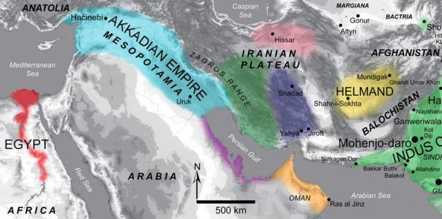
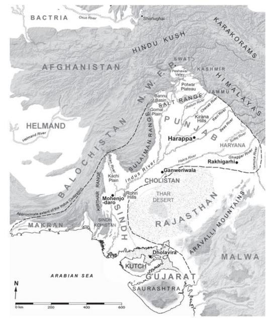
The Indus Civilization, at its greatest extent during the latter half of the third millennium BC (Figure 2.1), is variously estimated to have covered an area of northwestern South Asia ranging from 680,000 (Kenoyer 1991a: 352) to 1,000,000 square kilometers ( Jansen 2002: 105). Many Indus settlements are located in geographic regions well beyond the river valley that is its namesake. This prompted Rafique Mughal to propose (1970) the term Greater Indus Valley as a way to refer to the broader region that the civilization encompassed. The purpose of this chapter is to situate the focal point of this study – the site of Harappa, into the geographic, geologic and ancient temporal-cultural contexts of the Greater Indus* region (for brevity and consistency I hereafter drop *Valley from the term).
Geographic context
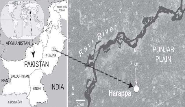
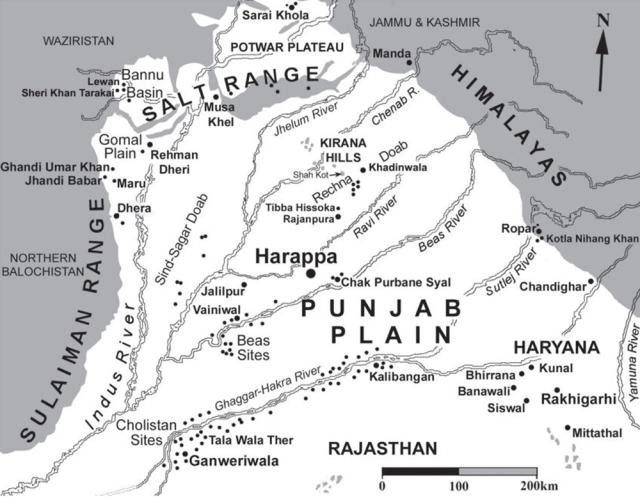
Harappa is located at N 30º 37’ 31”, E 72º 51’ 52” in District Sahiwal, Punjab Province, Pakistan. From that geographic vantage point in the center of the Punjab Plain near the Ravi River, the site was well placed in terms of access to resource zones both within and immediately surrounding the plain. It is also well situated in terms of other Indus settlements and large urban centers where rock and mineral resources from more distant areas could probably be indirectly obtained. In this section, I provide a brief and general overview of the major geographic features and regions of the Greater Indus region (Figure 2.1) and the principal routes through which residents of Harappa may have interacted with Indus peoples or other cultures living across this broad area. Much greater detail on pertinent features and regions are provided in upcoming sections and chapters.
The Kirana Hills – a series of rocky outcrops 120 km north-northwest of Harappa, are the first and only features in the general vicinity of the site that rise above the flat expanse of the Punjab Plain. On the plain’s western margin, 220 km from Harappa, the north-to-south running Sulaiman Mountains begin and from there numerous passes lead up into the highlands of northern Balochistan and from there to Afghanistan and the Helmand Basin. Moving northward, the next closest major features are the Gomal Plain, which is essentially a trans-Indus River extension of the upper Indus Basin alluvial plains and the Salt Range. From there low passes lead north into the Bannu Basin and Potwar Plateau. The most direct routes to the distant Indus Civilization outpost of Shortughaï, located in far northern Afghanistan, would have passed through these regions. Continuing clockwise, Harappans would have needed only to follow the rivers of the Punjab northeast as they passed through Jammu, Kashmir and into the western Himalaya in order to access the rich resources of those regions. Lying east of Harappa are the Indus settlements of the eastern Punjab and Haryana plains including the large urban center of Rakhigarhi, which might have provided indirect access to the resources of the northern Aravalli Mountains as well as the central Himalaya. To the south-southwest of Harappa, the Indus city of Ganweriwala and other related sites along the now dry Ghaggar-Hakra River system are points where interaction with ancient desert nomads in the Cholistan region (Mughal 1994b) who might have had access to the resources of western Rajasthan. The Ghaggar-Hakra and the parallel-running Indus River would have been the main southward routes from Cholistan and the Punjab toward the Sindh region and Mohenjo-daro, the largest Indus city. Raw materials from the Rohri Hills, the Kirthar Range, Sindh Kohistan and southern Balochistan may have passed northward to Harappa along these same riverine routes. From northern Sindh, it would have been possible to follow the Bolan River through the Kachi Plain and into the highlands of central Balochistan. Finally, from southern Sindh, a Harappan trader may have the traveled westward to Indus settlements and outposts in the Makran region or continued south to Gujarat and the Indus city of Dholavira.
The rest of Chapter 2 is in the attached PDF below.
Images
Figure 2.1 Map showing approximate extent (dashed line) of the Indus Civilization,
its five main cities and the major regions and features of the Greater Indus region.
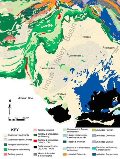
Figure 2.2 General geologic map of the Greater Indus region.
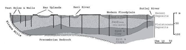
Figure 2.3 Cross section of the Punjab Plain looking northeast from Harappa.
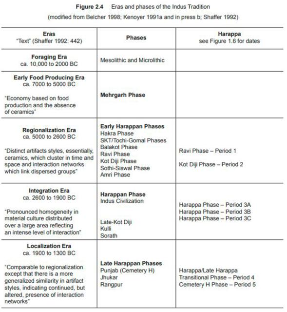
Figure 2.4 Eras and phases of the Indus Tradition
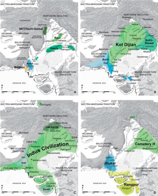
Figure 2.5 Select Regionalization and Integration Era sites of the Upper Indus Basin
Figure 2.6 Indus Tradition cultures of the Regionalization, Integration and Localization Eras
The Chapter section titles are:
Geographic context
(SEE ABOVE)
Geologic context
The Alluvial Plains
The Highlands
Temporal-cultural contexts
Traditions, eras and phases
Ancient settlements of the upper Indus Basin
The transforming cultural landscapes of the Indus Tradition
Regionalization era (Early Harappan Period)
ca. 3300 to 2800 BC
2800 to 2600 BC
Integration era – 2600 to 1900 BC
Localization era – 1900 BC to <1300 BC
Chapter conclusion
****************************
CHAPTER 3: STRATEGIES AND METHODS FOR SOURCING STONE AND METAL ARTIFACTS
Chapter Introduction – Strategies and methods
In order to address the lines of inquiry outlined in Chapter 1, it is necessary to know precisely what kinds of rocks and minerals are present in Harappa’s artifact assemblage and, for select varieties of those materials, to ascertain which geologic sources they were most likely acquired from. The purpose of this chapter is to review the various research strategies and methods that were employed to accomplish those two tasks.
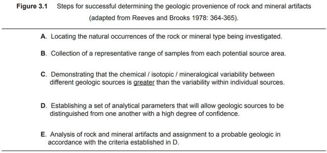
Reeves and Brooks (1978) outlined a series of steps (Figure 3.1) for successfully determining the geologic provenience of rock and mineral artifacts, which will serve as a guide for the presentation of this chapter. I begin with a discussion of the importance of utilizing the extensive body of geologic literature relating to South Asia as the primary reference source for locating the natural occurrences of the different rock or mineral types being investigated (Step A). Emphasis is also placed on the benefits of directly working with geologists. The discussion then shifts to the geologic field studies that were necessary for both collecting a representative range of geologic samples from each potential source area (Step B) and for confirming or refuting the existence and/ or nature of certain rock and mineral occurrences. I then move on to the issue that ultimately underlies the success or failure of any stone or metal artifact sourcing study – demonstrating that the chemical, isotopic or mineralogical variability between the different geologic sources under examination is greater than the variability within any individual source (Step C). Many factors contribute to successful source discrimination, such as the choice of sampling strategies (discussed in relation to Step B) and analytical methods (discussed in relation to steps D and E). One issue, which is often not given due attention, relates to the selection of the appropriate geographic scale on which to define stone or metal “sources.” After examining the issue of scale and the expectations of provenience resolution stemming from it, I proceed on a series of overviews outlining the various methods used to identify and/ or characterize archaeological and geologic samples for this study. Also discussed are the analytical methods that were chosen to evaluate the quantitative data obtained from the characterization of selected varieties of stone or metal. Through the application of these methods, parameters were established that allow different geologic sources to be distinguished from one another with a high degree of confidence and artifacts to be assigned to them based on their chemical/isotopic/mineralogical properties (steps D and E).
In the conclusion of this chapter, I stress that statements regarding the geologic provenience of stone or metal artifacts are always provisional, regardless of how comprehensive or statistically significant the datasets they are based on may appear to be.
Research strategies
In this section the research strategies that were used to identify potential rock and mineral sources, assemble a collection of geologic samples for analysis and to define suitable scales of provenience resolution are discussed.
In this section the research strategies that were used to identify potential rock and mineral sources, assemble a collection of geologic samples for analysis and to define suitable scales of provenience resolution are discussed.
Using primary geologic reference materials to locate potential sources
There have been several major broad-scale studies (Fentress 1976; Lahiri 1992; Ratnagar 2004) of Harappan trade networks that examined multiple varieties of stone and metal to construct models of proto -historic resource access and exchange. However, to identif y the rock and mineral sources that were potentially used in the past, those researchers relied heavily upon colonialera British Government district gazetteers and secondary references such as the source identifications suggested or cited by the writers of early excavation reports. Consequently, their interpretations have serious limitations due to the imprecise, incomplete and occasionally spurious nature of their principal reference materials. I am not suggesting that those types of sources are always wrong or have no value and should be ignored. On the contrary, the reports of late 19th and early 20th century civil servants and archaeologists are sometimes the sole source of information on certain mineral deposits. I myself frequently cite these references throughout this book. However, they alone do not provide a comprehensive picture of South Asian rock and mineral resources and, because their writers usually did not visit geologic occurrences themselves, misidentification of source locations and of the materials themselves could easily have been made. For these reasons, literature of this kind should not be considered the “best sources” (Possehl 1999: 173) to turn to for primary reference material when delineating potential resource areas for rock and mineral artifact provenience studies.
A substantial body of scholarly literature relating to the geolog y of South Asia exists and was accessed for this study as the primary reference material for locating potential sources of the rock and mineral artifacts found at Harappa and other sites. Among the most useful publications were those produced by national government agencies such as the Records, Memoirs and Bulletins put out by the Geological Survey of India and the Geological Survey of Pakistan. Publications by state agencies, such as the Department of Mines and Geolog y, Government of Rajasthan were also valuable sources data. Dozens of university geology departments in both India and Pakistan regularly publish journals, conference proceedings and books detailing the geologic resources of the state or region that they represent. For decades institutions such as Pakistan’s Centers of Excellence in Geology (Peshawar) and in Mineralogy (Quetta), the Geological Society of India (Bangalore) and the Wadia Institute of Himalayan Geology (Dehra Dun) have conducted and published groundbreaking geologic research. Public reports produced by organizations like the Gujarat Mineral Development Corporation (GMDC) and the Federally Administered Tribal Areas Development Corporation (FATADC) are also excellent sources of data on mineral resources in those areas. Newer geologic overviews (e.g. Bender and Raza 1995; Kazmi and Jan 1997; Ramakrishnan and Vaidhyanadhan 2008) have been published within the last decade or two that are far more accurate and comprehensive than earlier ones. Lastly, the unique nature of the Subcontinent’s geology has attracted researchers from around the world who have collaborated with their South Asian colleagues and published their results in a wide range of international journals.
The rest of Chapter 3 is in the attached PDF below.
Images
Figure 3.1 Steps for successful determining the geologic provenience of rock and mineral artifacts (adapted from Reeves and Brooks 1978: 364-365).
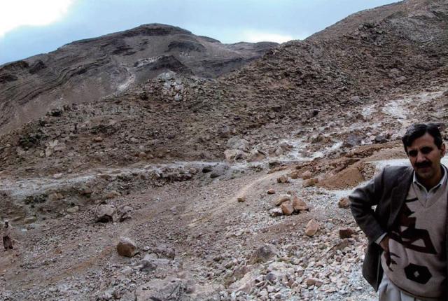
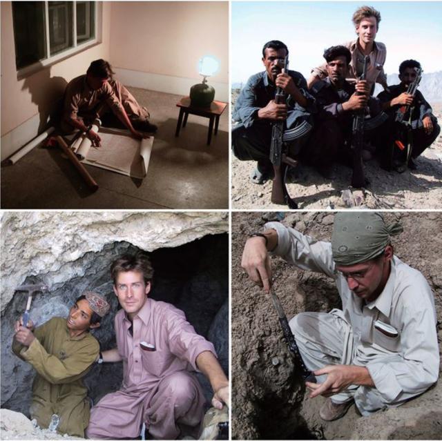
Figure 3.2 The author conducting fieldwork in Balochistan, Pakistan. Clockwise from top left - Consulting topo sheets in Muslimbagh, with levies in the Kanrach Valley, sampling steatite at Ugasai Nasir, and collecting bitumen in the Bolan Pass.
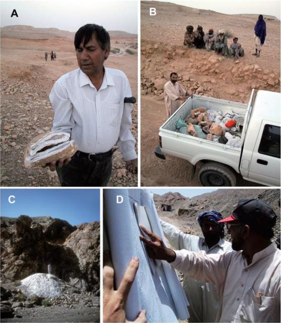
Figure 3.3 [A] Dr. S.R.H. Baqri (Pakistan Museum of Natural History) in the Rohri Hills, Sindh. [B] The sample-laden truck during my fieldwork with Dr. Baqri. [C] Dr. Khalid Mahmood (Centre of Excellence in Mineralogy, University of Balochistan) at the Tor Tangi steatite mine, Zhob District, Balochistan. [D] Khawar Akbhar (Geological Survey of Pakistan-Karachi) near Duddar, Las Bela District, Balochistan.
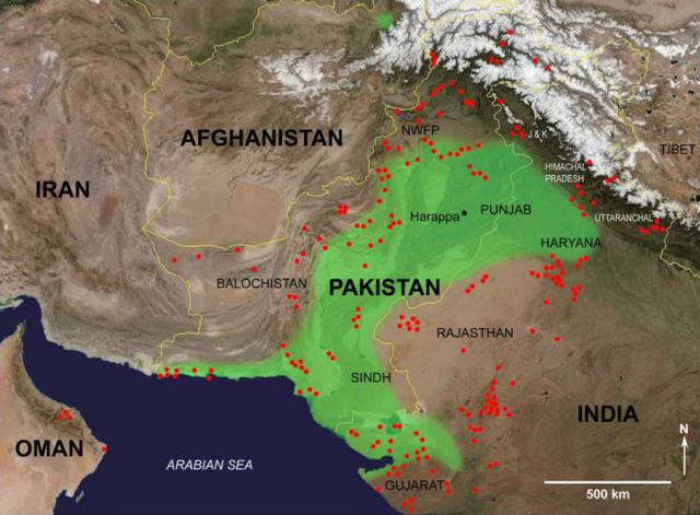
Figure 3.4 Locations (indicated by red dots) sampled ca. 2000-2010. The green shaded area represents the approximate extent of the Indus Civilization (ca. 2600-1900 BC).
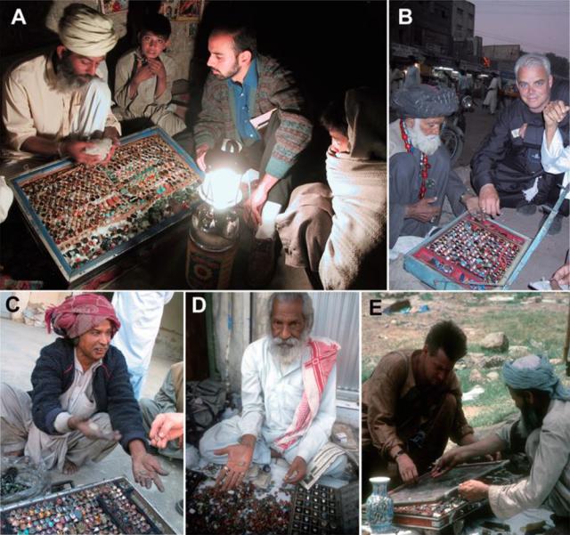
Figure 3.5 Visiting johris. [A] Mr. Sufkara Abbaas discusses a sample of Wayaro steatite in front of Abdullah Shah Ghazi's tomb in Karachi. [B] Dr. Mark Kenoyer looks through a johri's kabat in Karachi. [C] Mr. Ashiq Hussain, Khairpur, Sindh. [D] A johri in Agra, Uttar Pradesh. [E] The author looks through a johri's kabat in Islamabad.
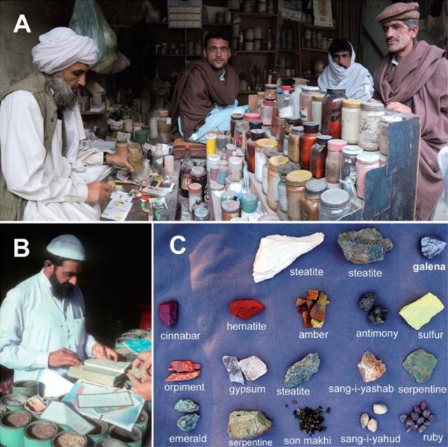
Figure 3.6 Visiting pansaris. [A] A pansari prepares remedies at his shop in Bannu, NWFP. [B] A pansari in New Attock City, Punjab Province, Pakistan consults a manual of traditional medicines. [C] The set of medicinal rocks and minerals collected from the New Attock City pansari.
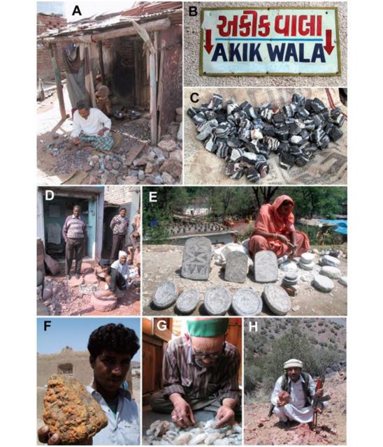
Figure 3.7 Various pattarwalas. [A] An agate bead-maker in Khambhat, Gujarat. [B] "Akik-wala" sign in Khambhat. [C] Bead roughouts of black jasper with white bands. [D] Millstone carvers in Agra, Uttar Pradesh. [E] A women carving querns and mullers, Katmandu, Nepal. [F] Mr. Aslam displays a specimen of fossiliferous limestone he collected in Las Bela, Balochistan [G] Mr. Bhagat Chang rummages through his collection of crystals from the Parvati Valley, Himachal Pradesh. [H] Mr. Malik collects hematite near Shin Kai, North Waziristan.
The Chapter section titles are:
Research strategies
Using primary geologic reference materials to locate potential sources
Field-checking and sampling potential Harappan rock and mineral sources
Tapping other sources of information: Johris, pansaris and pattarwalas
The “Provenience Postulate” and defining a geographic scale of provenience resolution
Methods of material identification and characterization
Visual inspection/comparison and basic mineralogical testing
X-ray diffraction (XRD) analysis
Electron microprobe analysis (EMPA)
Spectrometric analysis
Instrumental neutron activation analysis (INAA)
Methods of data analysis
Preliminary data analysis / bivariate plotting 62
Multivariate approaches 63
Choice of methods 63
Canonical Discriminant Analysis 63
Discrimination 63
Classification (and misclassification) 64
Cluster Analysis
Chapter conclusion – Statements of provenience