
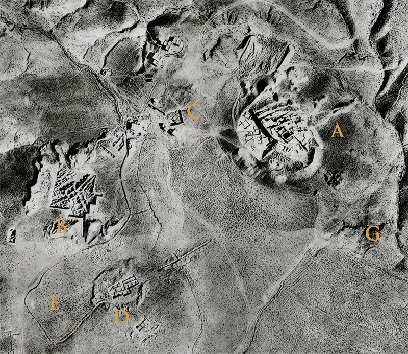
The expansion of Mundigak from Mound A to mounds B, D, E, F, G, H and I all seem to have happened in Period IV (2900-2400 BCE). "West of Mound A, Mounds B and D produced remains of an enclosing wall complete with square ‘bastions’. These structures were erected directly on virgin soil and consisted of two thick parallel walls of mud-brick resting on foundations of stone and clay. Regularly spaced rectangular projecting buttresses characterised the exterior wall, while the interior separating the two walls was divided into small rooms. The floors of these rooms had been raised significantly above the level of the exterior living surfaces. The frequency of stairways associated with these rooms indicates that access to either the roof or an upper storey was of some importance. This arrangement is seen in Oxus Civilisation architecture, and is also similar to the later Achaemenid ramparts at Kandahar, where the ‘rooms’ were interpreted as casemates," write Allchin, Bell and Hammond (The Archaeology of Afghanistan, 2019, p. 179).
It is possible that much of Mundigak, at some point in Period IV, was surrounded by a mud-brick wall, possibly including the "temple" on Mound G.
Dr. Gregory Possehl, connects Mundigak to the Damb Sadaat Phase of Central Baluchistan [4500-2000 BCE]: "Contemporary with the Kot Diji and Amri-Nal Phases is a smaller, more localized cultural phase of the early Harappan, centered on the Quetta Valley. It rests on a long history of occupation in this fertile, well-watered valley. Quetta-Pishin is blessed with substantial subsurface water resources, available even to relatively primitive cultivators in the form of artesian wells. This valley is also the center of a natural corridor linking southern Afghanistan to the Indus Valley via the Bolan and Khojak Passes. . .. There are thirty-seven Dumb Sadaat sites, twenty-nine of which have data on size. They average 2.64 hectares. The largest site is the Quetta Miri (23 hectares), located at one spot in the Quetta Valley that has been occupied continuously from prehistoric to modern times. The next largest site, Mundigak, is 18.75 hectares and is in the Kushk-i Nakhud Valley of the Helmand River drainage, over 200 kilometers to the northwest of the Miri. Mundigak was a town during Early Harappan times" (The Indus Civilization A Contemporary Perspective, 2002, p. 44).
Mundigak, throughout its history, been affected by cultures to the west in the Helmand Valley and the Iranian plateau, to the north by cultures and traditions from Central Asia, and to the south and east, by Balochi and Indus valley cultures. Although there is nothing quite like Mundigak during the height of Period IV in Afghanistan, it was not independent of developments in a full circle around it.
Image: Aerial View of the Mounds, from Casal, Fouille de Mundigak, 1961.