
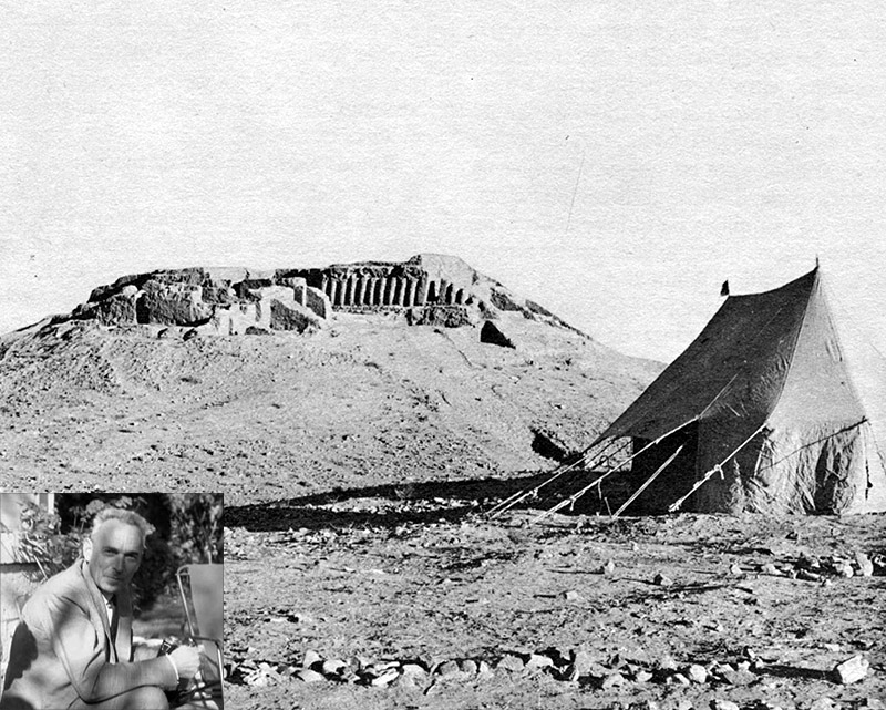
"The whole district was known as Kar Karez and the track eventually took us through a village called Mundigak, the name Jean-Marie had borrowed for the mound. High mud-brick walls, square, flat-roofed houses, all skirting the grey gravel of the river-bed, this was Mundigak village, but not our ultimate destination. The track still ran for several miles across the river bed and on to the next range of hills, but suddenly we turned off by a small cairn of white-washed mud-pise erected by the side of the road. This was the signpost to the dig.
"We turned towards the west across hard, dry, hilly ground split by crevasses and the stream beds through which no water flowed. We rocked and bumped, guided by the ancient tracks left by the vehicles last year and the year before that. Gradually the country resolved itself into a series of shallow mounds rising like air bubbles on freshly-beaten batter until we topped one of the bubbles to see the excavations crowning the highest mound of all."
- Sylvia Matheson, Time off to Dig, p. 52
Jean-Marie Casal (above, 1905-77), the French archaeologist who excavated the site between 1951 and 1958 wrote: "The site is located in the valley of Kishk-i-Nakhod Rud, now a dry tributary of the Arghandab [River], which sometimes is transformed for a few hours into a clear river when thunderstorms fall in the neighboring mountains. At the height of the site, this valley is almost parallel to that of the Arghandab. It is by a narrow road winding on the side of an arid and parched mountain, all of black stone, that one reaches it from the valley of the Arghandab to where the site of Mundigak rises. Only a few kilometers wide, the plateau extends to 1,400 meters above sea level between two bare chains. A few green islands mark the location of villages where water comes from the foot of the mountain through underground canals (karez),. Debris cones mark the ungrateful plain like lines of molehills. several hundred meters from the river and about two kilometers from the few houses in the hamlet of Mundigak which gave it its name. It is from this hamlet, as well as from other villages in the valley, some of which are distant from a ten kilometers, from which comes the labor force employed in the excavations. Local resources are scarce, and it is from Kandahar that the main source of supply and potable water for the [French Archaeological] Mission must come. Despite the short distance [55 km], it takes no less than two and a half hours for each journey.
"Isolated as it seems to be now, the Mundigak site surprises by its onetime importance. At first sight, the eye is struck by this head, shaped by the cone-shaped erosion, about twenty meters high above the plain, and wide at the base of about one hundred and fifty meters, extended towards the West and the South mainly by larger but less tall tepes [mounds] which indicate the extension that this establishment once took. The scattered pottery on the surface which approximates the extent of the ancient occupations hardly covers less than twenty hectares." (Jean-Marie Casal, L'Afghanistan et les problèmes de l'archéologie indienne, Artibus Asiae, Vol. 19, No. 3/4 (1956), from the French by Google Translate.)
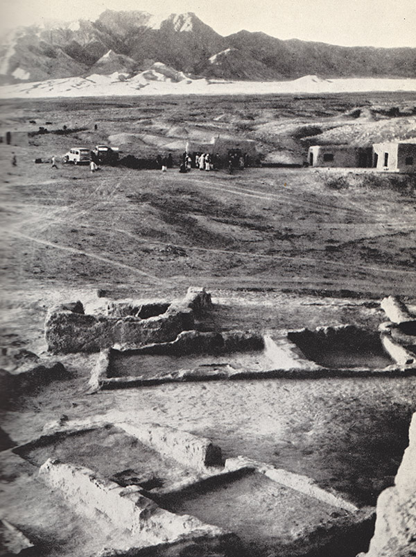
Image 2, from Matheson's Time off to Dig: "The camp at Mundigak, seen from the top of Mound A. The huts, our living quarters, are built of mud-pise [mud reinforced with straw]. In the foreground are remains of the earliest prehistoric dwellings, which had been buried under thirteen other habitation levels. The small oblongs with circles in the middle are the fireplaces. The photograph was taken on the last day of the dig when the workmen had gathered outside the mess hut to select their baksheesh."