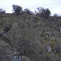
Overview of Trench 39 North, looking at the Harappan and Late Harappan Period levels. The brick wall is part of a large building that was constructed with wooden beams and columns.
The doors of later buildings can be seen in the upper levels of the wall to the left. The gradual tapering of the walls in the far right was an intentional architectural feature to avoid collapse of the upper floors.
The main street running north south along the east edge of the Great Bath ends with this unique brick platform. The hollow sockets would have held wooden beams that may have formed a gate or traffic control device.
Looking south along the street to the east of the Great Bath. In the foreground is a unique brick platform with hollow sockets used to place upright beams that may have formed a gate or traffic control device.
Looking north along the street to the east of the Great Bath. The building on the right is a single large structure called the College, and may have been the residence of priests or other elites (see Slide 38).
This street, called Divinity Street by the early excavators, has a small drain with brick coverings. The street runs north south along the east side of the College building.
The UM excavations conducted by Dr. G. F. Dales in 1964-65 exposed a massive mud brick platform that was used to raise a group of brick buildings several meters above the street level which was seen in the foreground.