

Kulli
Most sites in northern and central Balochistan were abandoned around 2600 BC. This development is probably related to the expansion of the Indus Civilization. Southern Balochistan, however, continued to be inhabited by a people labelled "Kulli."
This cultural complex is named after a site in Kolwa which was discovered by Aurel Stein. Since then, several other sites became known from Makran to southern Kalat, to Nausharo in the Kachhi plain, and to the eastern foot of the Kirthar Range in southwestern Sindh. Some motifs and vessel shapes found in southeastern Iran and on the Arabian Peninsula, are sometimes also linked to the Kulli and seen as indications for long-distance contacts.
 Several Kulli sites were discovered in our survey area (64). As a matter of fact, this phase coincided with the maximum number of settlements. The large number of settlements alon with the developed plan and large size of a couple of sites, in particular in the Hab- Saruna Valley, added a new and unexpected dimension to this complex.
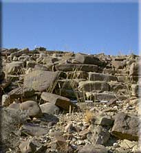
The lay-out of some sites resemble the plan of Harappan sites: Rows of houses are built along lanes and streets, which are sometimes paved. Sometimes, stairs provide access to upper terraces (65). Building materials were large ashlars or boulders, and the houses are often preserved to a considerable height.
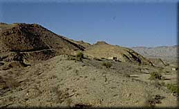
Many of these sites are located in strategic positions, on top of mountains or terrace hills, overlooking the valleys and controlling the plains and passes (66). Other sites are small hamlets built in the open plain. Although they have no defenses, they are of a very compact appearance. Most sites are associated with dams.
Bakkar Buthi is a small Harappan site located in the Kanrach Valley, a remote area bordered by the Mor and Pab Ranges.
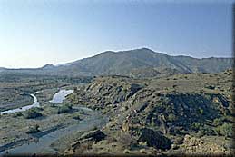
The site overlooks the valley from a terrace hill above the Kharari River, near the watershed of the Windar River (67). It was founded on the alluvium, but a small early third millennium BC site was discovered across the Kharari. Bakkar Buthi comprises of a fortified southern part and a couple of houses and working spaces which are obviously related to chert production to the north (68).
Two trenches dug in 1998 revealed several building phases built above a fine grained alluvial silt deposit (69)). Whereas the mudbrick and stone walls of the earlier phases were well-built (70, 71), the standards decline in the uppermost level where pottery and broken stones were also used for building (72).
The site is remarkable for its lay-out and the predominantly Harappan character of the pottery. Much of the pottery is identical to pottery from urban centers such as Mohenjo-Daro and Harappa, but wasters indicate also a local production (73, 74, 75, 76, 77). Kulli elements (78, 79) are more prominent than at Balakot, but, altogether, the assemblage is clearly different from that found on "classical" Kulli sites. A date between ca. 2400 and 2000 BC is supported by the radiocarbon samples. (80, 81, 82, 83, 84).
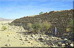
About 200m to the south, in an old and now dry meander of the Kharari River an impressive dam blocked the river just before its entrance to the Kanrach Valley. The huge dam which is the easternmost in a series of three dams, betrays a well advanced level of hydraulic engineering (85).
Greater Hab Valley
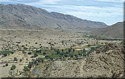
Following the Hab River from its mouth at the Arabian Sea towards north, the wide and fertile valley slowly rises and becomes intersected by spurs and several tributaries. North of the Bhootani Petrol Station, at the entrance to the Wirahab Valley, the typical topographical features, such as large north-south running river valleys and steeply rising mountain ranges take shape. The Andhar Range (86) which is marked by a flat top and deep fissures, rises to 1250m amsl, while the Kirthar and Khude Ranges reach 1400 meters and 1600 meters above seal level. The Hab Valley is wider and less steep than the Kanrach Valley. It thus has better potential for the accumulation of sediments and agriculture.
 During the surveys carried out in 1998 and 1999, 106 sites were discovered. Chronologically and culturally, they belong to the same horizon as the sites in the Kanrach Valley and the Las Bela plain. No real mounds were found, but, in general, the settlements tend to be larger than in the other areas (87, 88), and in Sind Kohistan. This is in particular true for the Kulli sites which cluster in large numbers between Dureji and Barag, and at points where tributaries such as the Loi, Bahlol, and Saruna Rivers enter the Hab Valley.
Nowhere were similarly large, nucleated towns found in such large numbers (89, 90, 91, 92). These settlements apparently formed a network controlling the access routes between Sindh and interior Balochistan. Unvariably, they are associated with dams, some of which are true masterpieces of construction (93, 94, 94b).
The pottery and objects found at these sites are clearly related to Harappan types (95, 96, 97, 98), but the fabric is usually coarser, the variety of shapes and motifs is smaller, and a number of local elements are also present. > 7